Zagreb Learning Landscapes 2022
>>>back to working groups overview
For help with editing this Wiki page use this link.
For more details on assignments and key readings please use this link.
| Area | Maksimir | |
| Place | Zagreb | |
| Country | Croatia | |
| Topics | Zagreb Light Plan | |
| Author(s) | Igor Jutrović, Monika Švagelj | |
| ||
Landscape Democracy Rationale
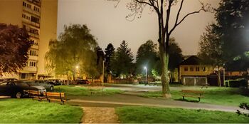
Public spaces become susceptible to delinquent behavior during late hours, especially in areas with poorer light infrastructure. Those areas are part of the city center and other important public spaces that are frequently used during the day.
Moving focus onto the dark and more intimate areas (patches) and connecting the areas with the living matrix or corridors of night infrastructure in the city, would improve the democratic use of public space, its safety and enjoyment at night.
Location and Scope
- You can edit this map with the map editor
Zagreb is the capital and largest city of Croatia and is subdivided into 17 city districts. Most of them are at a low elevation along the river Sava valley, whereas northern and northeastern city districts are situated in the foothills of the Medvednica mountain. The city extends over 30 kilometers (19 miles) east-west and around 20 kilometers (12 miles) north-south.
Maksimir city district is an old and safe district, known for Maksimir park, football stadium, and good schools. The central part of the district is mostly residential. The northern parts of the district are hilly, residential areas, with no high-rise buildings. Maksimir is subdivided into 11 sections (mjesni odbor), the location is a part of the Mašićeva subdivision.
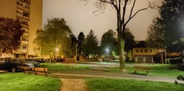
The chosen area is on flat terrain, surrounded by residential, high-rise buildings and a few public institution buildings (high school, elementary school, kindergarten, health center, cultural center), public parking, dog park, and playground.
Phase A: Mapping Your Community
Welcome to Your Community and Their Landscape
Socioeconomic status is the social standing or class of an individual or group. It is often measured as a combination of education, income, and occupation. People that live in this area have middle to high socioeconomic status. This is derived from factors like education, occupation, number of people in a household, and more. There are 100 – 150 people per hectare and the average age is between 44 and 47 years. The apartment area is on average 60 to 70 square meters. There are 4 to 5 % unemployed residents.
The lack of public spaces to enjoy at night is the local landscape democracy challenge. Light provides additional connections and allows us to experience the city differently, it also strengthens the feeling of safety through the correct way of lighting. More people in the streets at night generate greater social control and security. Other problems that we noted were too much pavement, vehicle advantage, no free drinking water, unsafe pocket gardens, etc.
Groups of Actors and Stakeholders in Your Community
- External actors are local government and public services responsible for the location: Local government office, ZAGREB HOLDING Ltd., ZRINJEVAC Subsidiary, Zagrebparking, Zagreb Police Department, Waste Management...
- Internal actors: Local residents (subdivided by age groups), Non-residental users (subdivided by age groups), Dog walkers, Education facilities - staff, teachers, parents and students/ children, Health center- administrators, practitioners, patients, Cultural center users, administrators and workshop leaders...
Relationships Between Your Actors and Groups
Time of the day had to be included for accurate power mapping of the location because time changes groups of users and their activities. The needs and
ways that location is used depends on the age gropes that are using the area. Blue represents night and yellow daytime hours. Circles are miclolocation where users mostly stay, play or hang around.
Shared interests AM:
NIGHT - Socialization- secluded gathering; Pets – dog and owner safety
DAY - Education – school, kindergarten, parking lots; Helth – parking lots, accessibility; Administration - parking lots, accessibility; Pets – green area accessibility, dog safety
Shared interests PM:
DAY - Recreation- park accessibility; Play- safety, shade, place to run; Creative learning – accessibility, parking lots; Pets – dog safety; Helth – parking lots, accessibility; Administration - parking lots, accessibility
NIGHT - Pets – green area accessibility, dog safety; Socialization- secluded gathering, Caffe bars
Summary of Your Learnings from the Transnational Discussion Panel
We need to make some small changes in the power mapping diagrams (too many numbers made it confusing).
Theory Reflection
Intervention research - The aim of intervention research is to initiate – through doing research – individual reflection and learning, which eventually leads to collective reflexivity and enlightenment. Social learning processes in practice are the key focus of intervention research and learning is the result of permanent reflection in a dialogue with scientists, rather than through adopting scientific knowledge provided by scientists.
Participation of civil society: An important catalyst for institutional change in the science system are civil society organizations, especially where they openly state their demands with regard to the role of science in the political arena and directly addressing scientific institutions. This can create the political momentum needed for substantial reforms. With regard to commercialization and industry interests there have been vast changes within the science system over the past decades. Similar mechanisms should be used in the context of societal interests and to establish a new contract between science and society.
-From: Schneidewind, Uwe et al (2016): Pledge for a Transformative Science - A conceptual framework
In a professional practice where social justice and landscape democracy are low on the list of priorities, participation does not figure among the preferred skills and experiences needed to succeed as landscape planning professionals (ASLA 2004). Not only have they limited knowledge about the theories and methods of community engagement, but they often see participation as an obstacle to their creative abilities and to the timely and successful completion of projects. Most of all, they are often unaware or ‘blissfully naive’ about the consequences of their actions and visions on the well-being of the communities they are seeking to serve (Hester 2008).
-From: LED Team (2019):Landscape Education for Democracy (Chapters 1-3, InBo Special Issue)
Landscape experience research follows either an objectivist paradigm, aiming to identify physical landscape properties that can be related to preferences or a subjective paradigm focusing on the psychological and sociological response. The first one is a landscape centred approach, the second one focuses on the observer and his/her social and cultural background.
-From: Kühne, Bruns et al: Landscape Culture - Culturing Landscapes
References
Ghent Light plan Lighting master plan Copper creek project
Phase B: Democratic Landscape Analysis and Assessment
Monika Švagelj, How do we experience the world around us?
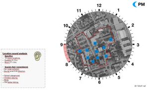
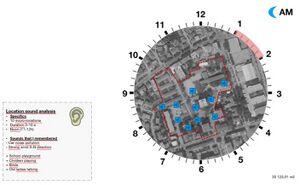
We experience the world through different senses, such as our sense of hearing, our sense of smell, and our sense of vision. When working on site analysis we oftentimes give more meaning to visual impressions, valuating them with more importance; concentrating on elements that are visually interesting, rare, or in another hand, impaired. By moving focus and thinking of other ways to perceive and analyze space, I tried to convey the feeling and impression of the location.
Place identity is an attachment in terms of emotional or symbolic meanings that are assigned by an individual. The physical landscape or place becomes part of a person’s self-identity.[1] Familiarity with a place can increase the strength of attachment.[2] Research has long shown that sound rooted in major chords tends to produce positive emotions and sounds rooted in minor chords produce negative emotions. On the other hand, sounds that we hear in everyday life often come to represent something to the listener, which affects the emotional response. If we think of our favorite places, it is likely that an individual will be able to easily navigate in their favorite space with their eyes closed. And for me to really understand what is important to that community and what THEIR needs for change are, first I need to get some field knowledge.
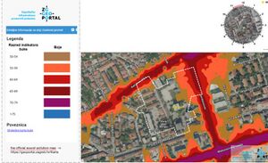
I took a look at the official sound pollution map and noticed that the most common source of pollution is cars.
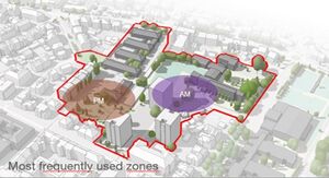
By overlaying power maps that we did for the last phase, I got 2 zones that are used more frequently during AM and PM, by different groups that change power over the location depending on what time of the day it is. Then I asked myself what do the zones sound like? How to show sound visually? And should I?
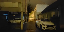
Sounds were recorded during 11-12 AM, 5-6 PM, 8-9 PM, and 1-2 AM, at the same locations, on different days.
During observation, I did not notice or record delinquent behavior.
For more understanding, it would be interesting to record during different seasons and to collect more data by recording in different locations.
Igor Jutrović, Perceiving space by sketch
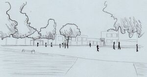
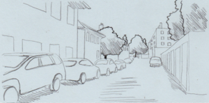
With a sketch, we can better perceive space and derive what is important and necessary to understand certain spaces. I tried to simplify certain spaces and better understand spacial differences and their connection with that in mind.
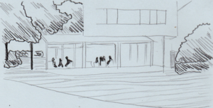
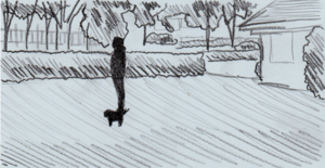
Walking around I recognized areas of interest. Those areas are represented in space with icons that best describe the feeling of the area, as shown in the picture to the left. The time of analysis was between 11h and 13h on a sunny day. Furthermore, I noted the number and type of users, the activity that they are performing, and the positive and negative attributes of that area. Recorded areas are as follows: School court; east side of the medical center, dog park and west side of the medical center, children playground (open), children playground (inclosed), area with benches and tables, asphalt area with benches, coffee shop, lawn south of the school. Sketches that represent Locations of interest are made with three types of line weight. Light strokes are ground and surrounding buildings, Middle strokes with hatches are vegetation such as trees and bushes, and heavy strokes are users of that location.
.
Location 1: School court
There were around fifteen users at the time. They were all children between 12 and 15 years of age. They were playing football on the large field.
Positive attributes of this area are sports activities, and a large open space that is secured from road infrastructure with a fence. On the other hand, negative attributes are seen as a necessity in the use of such place, and they are lack of water fountain, poorly illuminated at night, lack of vegetation buffer for noise, and with that lack of shaded areas.
Result:
A good place to be active with good access. It has only a football and basketball court but has great potential for its courts’ side space which can be used as resting areas.
.
Location 2: East side of medical centar
There were no users at the time, but from what we could see there are a lot of parked cars and garages, so we can say that it is used in periods of shift changes, in the morning and the afternoon. Users are workers and residents who own a garage on this street, and the activity is parking cars.
Positive attributes of this area are utilatery, work proximity, and passage to a road on the north (Petrova ulica; Petrova street). Furthermore, there are more negative attributes which result in poor space which it is not used. There are too many cars with not enough parking spaces, a lack of pedestrian pathways, and old light infrastructure.
Result:
Rarely usable space, only as parking space or pedestrian passage. Potential with pocket gardens and greenery near the building.
.
Location 3: West side of medical centar, dog park
A very narrow area that contains only one path connecting the parking lot in front of the medical center and Petrova ulica on the north. More used by pedestrians than location 2 passage. I saw only one pedestrian, and the main activity of that area is passing through.
Positive attributes are quick passage in direction north-south and the presence of pocket gardens that can be populated with lush vegetation. Negative attributes are empty dog park, narrow space, and old light infrastructure.
Result:
A narrow pathway is quickly used because of the fear for pets. The dog park is also, rarely used. The threat are people who are poisoning food and leaving it hidden for dogs.
.
Location 4: Children's playground
Open playground surrounded by a cultural center on the north, a street on the west and residential buildings on the south.it is slightly placed inwards from the street, and common types of users are children of all ages and their parents and guardians, who always accompany them. there are benches for the adults, and lots of playground elements for the kids.
There are 10 to 15 users, children and adults and the activity is playing.
Positive attributes of this place are safety, shade, distance from the road, variety of elements, and benches for the parents. On the other hand, negative attributes are visibility of the whole playground and the old light infrastructure.
Result:
Place with is mostly used and by a variety of users. We can safely say that this is the center point of the area and it is most lively.
.
Location 5: Children's playground (inclosed)
The playground is enclosed by a fence, which is a product of design. It is designed as a castle or a forth. it is completely empty despite just 2 meters across the fence is an open playground which is full.
Positive attributes of this place are safety, distance from the road, variety of elements, and benches for the parents. On the other hand, negative attributes are visibility of the whole playground, lack of shade, and the old light infrastructure.
Result:
Less used than an open concept playground but still in the center point of the whole open area. People are passing by, meeting here, and resting on the benches around the park.
.
Location 6: Park bench and table
This resting area is in a direct path of anyone who is crossing the park in the direction of east-west and is seen frequently used by all sorts of users. On the day of this analysis, there was one user, probably a student who was studying.
Positive attributes of this place are shade, distance from the road, which implicates no noise, from cars because of the vegetation which is creating buffer for the noise. Negative attributes are old light infrastructure and noise from the playground.
Result:
Studying in nature can be relaxing if all the needs for quiet and space are present.
.
Location 7: Park benches
This area is surrounded by three high-rise buildings (N, E, and S) and a park on the west. In the middle, there is a large asphalt area with 3 benches on the edge. People usually sit on the two south benches in the shade most of the time. Asphalt has permanent drawings that were made a long time ago so they are all washed out, and hard to spot at first.
Users are children, teens, adults, and seniors, and they are either passing by or sitting.
Positive attributes are the versatility of the space, and place to build upon. Negative attributes are old light infrastructure and noise from the playground, a small amount of high vegetation, no shade, and a big asphalt area.
Result:
Nice place to sit and relax but if there are more people someone will have to sit on the bench with no shade. A large asphalt area can be transformed into a green island with vegetation for shade and more noise dampeners.
.
Location 8: Caffe bar
This area is in direct path from elementary school to the plaground in the park. Also it is conection piont for pedestrians that walk in direction west-east, also it is in near proximity to roads. Terrace of the caffe bar watches on the ''location 7'' area. Users are all sorts, from teens, adults and seniors. there were around 8 to 10 people siting and conversing in the caffe at the time of analisys.
Positive attributes are shade, no disturbance from the road and no loud disturbing noise. Negative attributes are old light infrastructure, ugly fixed shader on the terrace of the caffe shop and small amount of high vegetation.
Result:
Fixed shader of the caffe can be made of vegetation and or make it less noticeable. On the other hand, it is a small caffe shop and it doesn’t pose and mayor problems.
.
Location 9: Public lawn
This area is a grass lawn with a live fence composed of Buxus sempervirens which separate it from the open asphalted area in front of the school. Because of the threat of food poisoning in the dog park people, usually come here to walk with their dogs and so they can relieve themselves.
Positive attributes are shade, no disturbance from the road, and no loud disturbing noise. Negative attributes are old light infrastructure, an ugly fixed shader on the terrace of the coffee shop, and a small amount of high vegetation.
Result:
Lawns are used for dog walking because they are safer than a dog park. Dogs are on the leash, and owners are watching for anything suspicious in the grass. Safety of the pets is necessary but also poor.
Phase C: Collaborative Visioning and Goal Setting
The Scene in Your Story of Visioning
LANDSCAPE DEMOCRACY CHALLENGE
Due too the diferent user groups of high intencity used area, site is susepteble to delinquent behavior during late houres. Residents feel lack of control and safety during all houres in thair part of neighborhood. The lack of sence of community and its patipcipation in local mathers
PROBLEM-STATEMENT
Lack of public spaces to enjoy at night: Light provides additional connections and allows us to experience the city differently, it also strengthens the feeling of safety through the correct way of lighting. More people in the streets at night generate greater social control and security.
Too much pavement, vehicle advantage, no free drinking water, unsafe pocket gardens, noise, bad zoning, lack of engagement of surrounding institutions, poorly arranged shrubs and bushes, and lack of communal activities.
The Actors in Your Story of Visioning
- INTERNAL ACTORS
- EXTERNAL ACTORS
The Story of Visioning
The largest group of actors and most predominant are children and with that, we should acknowledge their input in what they want. Following on children are their parents, and caretakers who are with them. They also use space in high value.
The next group is seniors whose daily recreation is walking and relaxing in the park. We should let them speak and tell us what would their long-year knowledge of their space make more accessible to them.
And the last group are workers and visiting citizens who come here for the institutions and use this public space for a shorter time.
The visioning process can be taking place on-site, in the most used areas of the park, also it needs to be seen from the distance and inviting. Those places can be located as shown on the map. The time of the visioning process would differ depending on the actors, but most of the actors are gathering after their jobs in the afternoon, towards the evening.
- CREATE WORKSHOP FOR ELEMENTARY SCHOOL, SKETCHING, COLLAGE TO CHILDREN IN DISCUSSION ABOUT WHAT THEY NEED
Connecting with school administration and teachers workshop could be created as part of arts and crafts subject which would take place in the park. The school could bring out chairs and tables, children could bring their own media of art (pencils, paint, colleague,…) We could present the project to them in a way that they can understand. But only as questions that we would ask them about the area and a park. For example:
•Is the space safe, and how would it be more accessible to them;
•What would they like to have in the park or near school;…
The workshop could also be later in the afternoon so that the parents and caretakers can also participate and say what they think their children’s needs are.
- GRAFFITI WORKSHOPS, STREET ART WORKSHOPS
Collaboration with a cultural center can result in a workshop in graffiti making. As their building has large murals and some are in an awful state, they can be recreated or remade completely new. They could create an event, provide paint and brushes, and invite people to hang out and create art and through that a community. Cultural center could also create events such as clean-up, outdoor activities and actions that would be in a park area.
Reflect on Your Story of Visioning
- FORMULATING GOALS
First and foremost, we need to consider time. Everyone works differently and children have school in different shifts (morning and evening). So, with an analysis of people’s movement throughout the day, we can determine when would be the best time for any sort of participation of certain or all actors. Another thing we have to consider is the lack of communication and informing the public.
By creating a stronger community that is involved in public space around their residence people would be connected and informed. Creating a group on social networks or creating events for their neighborhood, would straighten the community
- CHARACTERISTICS OF A ‘GOOD’ VISION
1.Define what you do as an output
2.Define what unique twist you and other organization brings to the above outcome
3.Applying some high-level quantification
4.Add relatable, human, 'real world' aspects
- SWOT ANALYSIS
Phase D: Collaborative Design, Transformation and Planning
Your Prototyping Action
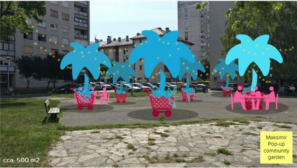
One of the problematic zones is asphalted area east of the children's playground. Some of the problems that we noted are:
- Noise pollution - bad acoustics and vehicular noise
- Heat-affected zone
- Big unused asphalted area
- Lack of urban equipment for the older population
To secure interesting space for community reconnection we proposed to use cheap and movable objects that are used as big planters (cart, trolley, or crate) for fruit and decorative trees. The idea came from NL architects' project. A pop-up community garden would offer movable shade for users to sit and hang around, and also help with zoning and designing future permanent green islands on the location.
Movable trees and sitting equipment would also come with ambient light (string light, small reflector) that could offer more visibility and security during late hours. To remove the potential problem of delinquent behavior and noise during early hours, lights would be turned off and trolleys would be chained to the nearest benches.
Link to Mural page. We asked our audience to take the role of residents and question how would they feel if this kind of attraction pops up under their window. We secured an interactive space for the audience to interact with us.
We learned that we should combine fruit trees and decorative trees to that we get better shading. It should be built from recycled materials, and not plastic. If residents plant herbs they will feel more connected. There should be a time limit so the attraction doesn't disrupt sleep. For a more permanent solution, we need phase one that shows us where people want trees and how they will shape zones and move objects.
Phase E: Collaborative Evaluation and Future Agendas
Collaborative Evaluation and Landscape Democracy Reflection
- Reevaluation of the local landscape democracy challenge:
- Lack of public spaces to enjoy at night
- Due to the different user groups of high-intensity used areas, the site is susceptible to delinquent behavior during late hours.
- Residents lack control and safety during all hours in the neighborhood.
- The lack of sense of community and its participation in local matters.
The Actors in your Collaborative Evaluation
The largest group of actors and most predominant are children and with that, we should acknowledge their input in what they want. Following on children are their parents, and caretakers who are with them. They also use of space in high value. The next group is seniors whose daily recreation is walking and relaxing in the park. We should let them speak and tell us what would their long-year knowledge of their space make more accessible to them. And the last group are workers and visiting citizens who come here for the institutions and use this public space for a shorter time. The visioning process can be taking place on-site, in the most used areas of the park, also it needs to be seen from the distance and inviting. Those places can be located as shown on the map. The time of the visioning process would differ depending on the actors, but most of the actors are gathering after their jobs in the afternoon, towards the evening.
Evaluating the process together with the community
After collecting the raw data we can extrapolate the necessary information on what are the most common patterns of element displacement and create a panel that can be put on site to show people what did they create and how to do those ideas work and why. Encourage them to recreate or create new patterns.
How the different stakeholders take part in the monitoring process
With a movable garden, stakeholders can show us where they want the trees, by moving elements around. Different stakeholders would maybe move elements differently. For example, children could move them to the sides for maximum centar space for playing and drawing on the asphalt. Teens could make little groups of elements to sit around and converse. Adults would maybe move all elements in the middle for all-around moving and watching angle.
Collected monitoring data
Data could be collected periodically throughout the day, in the forenoon and the afternoon, two or three times a week for a month or two in the winter, spring, summer, and fall. Monitoring data can be in form of images or posts on social media. Organized events, such as late-night hangouts can contribute to spreading information to the community and therefore interest the people to interact with the prototype.
Collected picture data can be converted into the plan form which is better envisioned through more eye-pleasing forms. Indicators for creating the plan are the moveable tree elements which paint us a clear picture of where the stakeholders would want the trees to be put. Stakeholders were included in process of building moveable elements and planting foliage and trees in those objects (creates). Latter they are reporting their images on social media with a specific hashtag. And last by deciding what version of the plan would they like the most.
Reflection on the Online Seminar
- insert text here
- Addyouruniqueimagename.jpg
insert text here
- Addyouruniqueimagename.jpg
insert text here
- Addyouruniqueimagename.jpg
insert text here
Process Reflection
- insert text here


