LED Online Seminar 2018 - Working Group 2
--> Back to working group overview
Dear working group members. This is your group page and you will be completing the template gradually as we move through the seminar. Good luck and enjoy your collaboration!
Assignment 1 - Reading and Synthesizing Core Terminology
- You can read more details about this assignment here
- Readings are accessible via the resources page
Step 1: Your Landscape Democracy Manifestoes
-
 Amsal's manifesto
 -
 Patrizia's manifesto
 -
 ahmed's manifesto
 -
 Mehrnoosh's manifesto
 -
 Oumeima's manifesto 1
 -
 Oumeima's manifesto 2
 -
 Lubna's Manifesto


-visual_manifesto.jpeg)


Step 2: Define your readings
- Please add your readings selection for the terminology exercise before April 18:
A: Landscape and Democracy
B: Concepts of Participation
Mehrnoosh Rahimian: The Right to the City: David, Harvey (2003)
Ahmed Abdelhafaz: Evaluating Community Design, Landscape Journal, Hester, Randolph (2012)
Amsal Mešić: Day, Christopher (2002): Consensus Design, Architectural Press
C: Community and Identity
Patrizia Eben: URBACT programme, The European Territorial Cooperation programme aiming to foster sustainable integrated urban development across Europe
Mehrnoosh Rahimian: Cinematic Landscapes by Welk Von Mossner, Alexa (2014).
D: Designing
Amsal Mešić: Smith, Nicola Dawn (2012): Design Charrette: A Vehicle for Consultation or Collaboration
Hester, Randolph: Democratic Drawing - Techniques for Participatory Design
Mehrnoosh Rahimian: Pritzker Prize winning architect Alejandro Aravena on sustainable design and community involvement in Chile
E: Communicating a Vision
Steps 3 and 4: Concepts Selection and definition
- Each group member selects three relevant concepts derived from his/her readings and synthesize them/publish them on the wiki by May 9, 2018
- Group members reflect within their groups and define their chosen concepts into a shared definition to be posted on the wiki by June 6, 2018.
- Other group members will be able to comment on the definitions until June 12, 2018
- Each group will also report on their process to come to a set of shared definitions of key landscape democracy concepts on the wiki documentation until June 20, 2018
Concepts and definitions
Author 1: Amsal Mešić
- Day, Christopher (2002): Consensus Design, Architectural Press: In a proper democracy, discussion should be valued more than mere voting. When several options are presented, mere voting can often lead to the dissatisfaction of the majority. Discussion, on the other hand, leads to a consensus on which design would suit everyone's needs and desires or at least it can produce a viable compromise.
- Smith, Nicola Dawn (2012): Design Charrette: A Vehicle for Consultation or Collaboration: The design charrette encompasses tools used in the early phases of the design process, whereby main stakeholders are encouraged to work together with the designer. This ensures that the design process is quicker and more interactive.
- Hester, Randolph: Democratic Drawing - Techniques for Participatory Design: Painting, collage, sketching, collage and other creative methods are used express ideas and thoughts. Drawing is an attempt add value to the space in the eyes of the people. This makes collaboration very important.
Author 2: Patrizia Eben (URBACT)
- involving inhabitants & relevant key stakeholders in the development of local policies
- sharing knowledge with other European cities working on the same problems (transnational exchange)
- developing sustainable solutions that integrate economic, social and environmental urban topics
Reference: http://urbact.eu/
Author 3: Ahmed Abdelhafaz
- Legitimacy: The participatory process for community development and the social considerations by Democratic Process- Community Considerations - Environmental Justice and Learning Opportunities, Reference: Evaluating Community Design, Landscape Journal, Hester, Randolph (2012)
- The scored awareness: a common language among participants that learn their feelings, not intellectualize them by resources (R), valuation (V), and performance (P) process, Reference: Evaluating Community Design, Landscape Journal, Hester, Randolph (2012)
- Consensus: Extensive ‘listening’ and ‘collective goals setting to lead to creative consensus, Reference: Evaluating Community Design, Landscape Journal, Hester, Randolph (2012)
Author 4: Mehrnoosh Rahimian
- Finding the Right Question: Participatory design process is not really a way for finding solutions about problems. It is a manner to identify what is the right challenge and question. To design a space well, the main step is identifying needs of people through asking it from themselves and it means participatory design process (Pritzker Prize winning architect Alejandro Aravena on sustainable design and community involvement in Chile).
- Landscape as a setting of the life whether in the real world or even in fiction films; The landscape plays an active role not only in our lives but also in the filmic narratives. In the other words, the stories of the narrative heroes take place in the cinematic landscapes as same as our lives that depends on the landscapes (Cinematic Landscapes by Welk Von Mossner, Alexa,2014).
- To achieve democratic control on urbanization; It calls "The Right to the City". the right to the city is far more than a right of individual access to the resources that the city embodies: it is a right to change ourselves by changing the city more after our heart's desire (The Right to the City: David, Harvey,2003).
Author 5: ...
- ......
- .......
- .......
Author 6: ...
- ......
- .......
- .......
Step 5: Reflection
Landscape Democracy is a form of planning, designing & developing sustainable solutions in which all citizens are meant to participate equally, either directly or presenting ideas to the people in a clear way. They are building a consensus or a compromise through discussions or elected representatives in the proposal and develop and establish rules by which their landscapes and open spaces are shaped.
Step 6: Revised manifestoes
- please look again at your initial manifestoes and update them with any new aspects/prespectives you have taken up during this seminar
-
 Author1's updated manifesto
 -
 Patrizia's updated manifesto
 -
 Landscape Democracy is a form of planning, design & development for sustainable landscape solutions in which all people are meant to participate equally, either directly or presenting ideas to others in a transparent way and building a consensus or a compromise through discussions, elected methods.
 -
Author4's updated manifesto
-
Author5's updated manifesto
-
Author5's updated manifesto


Assignment 2 - Your Landscape Symbols
- You can read more details about this assignment here
Landscape Symbols Author 1: Amsal Mešić
-
 The Partisan cemetery was once a stunning monument to the brotherhood and unity of Yugoslav peoples, while its present neglect and desecration reflect the reign of ethnic nationalism in modern-day Mostar and Bosnia-Herzegovina.
 -
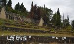
 Počitelj is a picturesque 16th century town in Bosnia-Herzegovina. Due to a lack of communication with various levels of government, the families that have lived there for centuries now consist of a few elderly people. The stone walls, cemeteries and orchards are being swallowed by ivy and bushes.
 -
 When these plane trees were planted, Mostar was part of the realm of the Emperor of Austria, the building was the mayor's residence, and the street was named in honor of the Crown Princess. Fast forward a century, and Mostar does not have an emperor, a princess, or a mayor's residence, but the plane trees have grown big and strong.


Landscape Symbols Author 2: Patrizia Eben
-
 Herzoggarten Landshut, Germany
 -
 Roadside Cross, Altdorf, Germany
 -
 Nuclear Power Station Isar, near Landshut, Germany


Landscape Symbols Auther 3: Ahmed Abdelhafaz
-
 The Central Park(New York/ USA)Historical & political symbolic: Referring to a historical background of this the park which designed related to the city's need for a public park at this time.
 -
 The National September 11 Memorial & Museum (New York City / USA)-Memorial symbolic: Remember and honor the thousands of innocent men, women, and children murdered by terrorists in the horrific attacks of February 26, 1993 and September 11, 2001.Respect this place made sacred through tragic loss.Recognize the endurance of those who survived, the courage of those who risked their lives to save others, and the of all who supported us in our darkest hours.
 -
 The Lincoln Memorial Reflecting Pool(Washington / USA)-Memorial & Events symbolic: the reflecting pool is right in front of the Lincoln Memorial, many famous events have happened there.
 -
 The combined symbols.
 -
 The combined symbols.


Landscape Symbols Author 4: Mehrnoosh Rahimian
-
 Naghsh-e Jahan Square was the core of Isfahan city, Iran constructed between 1598 and 1629. Nowadays, it’s an important historical site for tourists and one of UNESCO’s world heritage sites. The square is surrounded by buildings from the Safavid era. The Shah mosque on the south side and Sheikh Lotf Allah mosque on the eastern side of this square were served as a religious pole of the city. The Ali Qapu palace on the west side of the square was as a government center, and finally on the northern side, Keisaria gate opens into the Isfahan Grand Bazar and It has been operated as a commercial part of the city. It is the historical and memorial symbol referring to a historical background of the site and the manner of expanding the city in Safavid era.
 -
 Chahar Bagh Boulevard is a historical avenue in Isfahan constructed in the Safavid era of Iran. The avenue, historically, is the most famous. It connects the northern parts of the city to the southern sections and is about 6 kilometers long. This historical avenue could be as a landscape symbol and even cityscape symbol too. It serves as an open space gathering people together for social communication, economic activities and recreations. It is the historical and memorial symbol referring to a historical background of the site and the manner of expanding the city in Safavid era.
 -
 The Shah mosque is a mosque in Isfahan, Iran standing in south side of Naghsh-e Jahan square, built during the Safavid empire. It is regarded as one of the masterpiece of Persian architecture in the Islamic era. Even though, After Iranian revolution the name of this was changed and called Imam mosque but it always remembers the glory and majesty of the Iranian history and culture.
 -
 Grand Bazar was originally constructed during the 11th century, on the southwest wing of Shah Mosuq (Jameh Mosque) and Kohneh Squre but various arcades and rooms were later added to it. The present remnant dates from the Safavid period, during which the Qaysariya Bazaar was built on the north wing of Naghsh-e Jahan Square, a square which was developed as a substitute for Kohneh Square. The bazaar, one of the oldest and largest bazaars in the Middle East, dates to Saljuqid and Safavid era and is the longest roofed market in the world. The site has been destroyed several times and the contemporary bazaar dates to the 17th century. The bazaar is a vaulted two-kilometre street linking the old city with the new. Indeed, It a commercial and historical core (symbol) of the Isfahan city gathering citizens together for economic and social interactions.


Landscape Symbols Author 5: Oumeima Lajnef
-
 Sidi Bou Said is a Tunisian city located on the top of a cliff, around 20 km from Tunis, the capital. In the 12th century, Abu Said El Beji arrived in the village and what is previously named “Jbal El Mnara” and established its Sufi sanctuary, that became later on his tomb. In the 1920’s, Rodolph d’Erlanger, a French baron, applied the blue and white colors in all the city buildings. Thanks to its bright colors and light, Sidi Bou Said have inspired many famous artists such as Paul Klee and Gustave-Henri Jossot. Know days, the city is known for its art galleries, its phenomenal views on the Mediterranean see and the bay of Tunis, its typical Tunisian architecture and its welcoming cafés. That what makes it today a Tunisian symbol.
 -
 Located around 270 km south east of Tunis (the capital of Tunisia), Sfax is was built over the ruins of Taparura. Nowadays, Sfax represents an industrial capital for the country. The town was mainly formed by the ‘Medina’: a big fortress surrounded by high walls. Inside the ‘medina’ the streets are structured as if they were a maze. The particularity of the medina of Sfax remains in its stability: No changes has been made on its structure through the years. This is why it was considered as a national historic monument conserved by the United Nations. It is currently the best example of the old Arab Muslim town. The originality of Sfax’s medina remains also in its souks (markets): All the souks are organized according to their specialties (wool, Chechia (old hat), jewelry, fabric…) and named after them. This picture was taken in one of these souks, in an old house that was converted into a fabric store. It represents the souks, the old Tunisian architecture and wall decoration.
 -
add a caption (one paragraph max) description of the symbolism, interpretation, as well as geo-location


Landscape Symbols Author 6: ...
-
 Lubna Mansour-Landscape Symbols (one paragraph max) description of the symbolism, interpretation, as well as geo-location
 -
add a caption (one paragraph max) description of the symbolism, interpretation, as well as geo-location
-
add a caption (one paragraph max) description of the symbolism, interpretation, as well as geo-location

Assignment 3 - Role Play on Landscape Democracy "movers and shakers"
- You can read more details about this assignment here
Assignment 4 - Your Landscape Democracy Challenge
- You can read more details about this assignment here
- Each group member will specify a landscape democracy challenge in his/her environment
- Each Landscape Democracy Challenge should be linked to two or three of UN's 17 sustainable development Goals
Landscape Democracy Challenge 1: Amsal Mešić
- A Withering Landscape
-
The historic urban site of Počitelj is a national monument of Bosnia and Herzegovina and is included in the tentative list of UNESCO World Heritage sites. Along with the surrounding countryside featuring vegetable gardens and orchards, Počitelj forms a unique landscape.
-
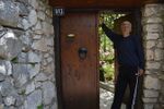 The essence of Počitelj as a landscape of national (and possibly global) value is human activity. With Počitelj following the increasing trend of population aging and emigration from Bosnia and Herzegovina, the threat of desertification looms. Its stone walls and cobblestone streets are in danger of being swallowed by ivy, as its gardens already have been.
 -
 Unplanned construction is putting Počitelj's valued historic character in jeopardy. Due to poor relations between the municipal authorities and the inhabitants of Počitelj, the proposed regulations have been vetoed. Tourism opportunities entice the otherwise reluctant and rapidly aging population to remain in Počitelj, but both depend on proper regulations and support from the authorities.
 -
 Meeting the needs of the local population is vital for the preservation of Počitelj. That necessitates reasonable cooperation between the local authorities and the inhabitants.
 -
 Achieving UN's Sustainable Development Goal 8 is crucial, as people need jobs to stay and maintain the landscape.
 -
 UN's Sustainable Development Goal 9 is important because there must be room for reasonable development even within a historical landscape.


Your references:
- Maglajlija, Vedrana (2016): Počitelj - zaboravljeno blago u dolini Neretve, Al Jazeera Balkans
Landscape Democracy Challenge 2: Patrizia Eben
- B15neu from Regensburg to Rosenheim - a long-lasting process and much discussed topic
-
 Due to the construction of B15neu and many detours there is a high traffic density and frequently traffic jams in Landshut and its neighbouring communities at the moment.
 -
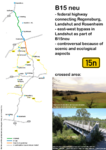 The B15neu is a federal highway connecting Regensburg, Landshut and Rosenheim. In the northern part it is still finished or in process of construction, but the southern continuation from highway A92, which is also an east-west bypass for a relief of traffic in Landshut, is very controversal. There is a huge opposition in the population because of scenic and ecological aspects (for example crossing the Isar and protected areas).
 -
 There are some pros and cons about the construction of B15neu that must be weighed.
 -
 As a result of various positive and negative aspects, the opinions are divided. There are many proponents as well as oponents.
 -
 The 9th goal of the UN`s Sustainable Development Goals is fulfilled by the construction of B15neu.
 -
 At the same time the goal number 15 is not fulfilled in many points.


References:
- http://www.pro-b15neu.de/home.html
- http://stop-b15-neu.de/
- https://www.un.org/sustainabledevelopment/sustainable-development-goals/
Landscape Democracy Challenge 3: Ahmed Abdelhafaz
- Landscape Elements as a tool for sustainability of the historic districts.
-
 caption: Al Darb Al Ahmar, Old Cairo, Egypt: I selected this case because it is a clear example for urban growth for the old and historical Cairo districts which showing the disappearance of green areas & landscape inside the urban shape and the government challenge to create a green spaces inside the existing urban to make an environmental and visual balance .
 -
 caption: conflict (1): This historic area is an appropriate location for New Construction, this issue leads to poor urban planning and different problems such as traffic, sound, and air pollution. In addition, It is clear that Cairo needed more green space and some studies found that the amount of green space per inhabitant is roughly equivalent to the size of a footprint.
 -
 caption: conflict (2): The presence of more than one area in the heart of the old neighborhoods as a municipal rubbish dump, which visually distorts the value and culture of these areas.
 -
 caption: who are the actors? A government, private sector, civil society and international organization, Academic and experts and citizens ideas.
 -
 caption: UN's Sustainable Development Goal? The 11th goal of the UN`s Sustainable Development Goals( Make cities inclusive, safe, resilient and sustainable) was fulfilled by the construction Al Azhar Park inside the urban area in Al Darb Al Ahmar
 -
 caption: UN's Sustainable Development Goal? The 13th goal of the UN`s Sustainable Development Goals was fulfilled by the construction Al Azhar Park inside the urban area in Al Darb Al Ahmar which created a huge green area (30 hectares) and was a reason for new environmental balance for humans, planting and birds in this district.
 -
 caption: UN's Sustainable Development Goal? The 15th goal of the UN`s Sustainable Development Goals was fulfilled by the construction Al Azhar Park inside the urban area in Al Darb Al Ahmar which created a huge green area (30 hectares) and was a reason for new environmental balance for humans, planting and birds in this district.


Your references:
- http://jfa.arch.metu.edu.tr/archive/0258-5316/2008/cilt25/sayi_1/105-125.pdf
- http://ismaili.net/timeline/2004/20040507an.html
- http://www.akdn.org/publication/al-azhar-park-cairo-and-revitalisation-darb-al-ahmar
Landscape Democracy Challenge 4: Mehrnoosh Rahimian
- Passing the subway line under the historical Chahar Bagh Street and monuments in its vicinity in Isfahan, Iran
-
 caption: why did you select this case? One of the landscape democracy challenges we face in our environment is construction projects and infrastructure developments. Isfahan Subway expansion is indeed one of the most complicated construction projects in Iran, as the numerous historical sites across the Isfahan city have to be preserved during the underground excavation of the subway line.
 -
 caption: what is the issue/conflict (1) After the numerous warning from Iranian Cultural Heritage Organization about preserving the historical monuments and despite all the oppositions, the 12 Km line 1 passes under the historical Chahar-Bagh street and monuments in its vicinity. Meanwhile, Plans on the construction of metro line 2 shows that this is likely this line will pass nearby the historical Naghshe_Jahan square. So there are some concerns about the safeguarding of this famous square too. This picture shows discovery of the foundations of the ancient palace recently in Isfahan on the path of the subway line. It raised concerns over the fate of the newly-excavated historical site. Unfortunately the construction of the subway has destroyed every historical monuments that happened to be on its way.
 -
 caption: what is the issue/conflict (2) this project have been so Controversial because of the long-term construction. it have blocked the historical street for a long time and caused financial damages for its stores and also disorder and visual chaos for users and made barriers to pedestrians.
 -
caption: who are the actors? The government, the urban train organization, the private sectors in construction affairs who benefit from this project and the people and citizens are the users but worried and dissatisfied.
-
 caption: UN's Sustainable Development Goal? Referring to the goal number 9: this project despite the decreasing traffic volume and improving the equality in accessibility for citizens is not a sustainable infrastructure because of the lack of sustainable planning, mismanagement and proper decision making on its path.
 -
 caption: UN's Sustainable Development Goal? Based on goal number 11: it's not affordable because of the high costs due to inappropriate rout. It have taken about 15 years and for a long time this street was blocked because of the construction and this caused the stores located in the street much more financial damages.


Your references:
- https://financialtribune.com/articles/people/37707/isfahan-subway-moves-on
- https://financialtribune.com/articles/people-travel/21153/unesco-urges-more-iranian-conservation-measures?utm_campaign=more-like-this
- https://en.mehrnews.com/photo/111202/Historical-objects-discovered-in-Isfahan-subway-excavations
- http://www.payvand.com/news/06/jul/1065.html
Landscape Democracy Challenge 5
- Give a title to your challenge
-
caption: why did you select this case?
-
caption: what is the issue/conflict (1)
-
caption: what is the issue/conflict (2)
-
caption: who are the actors?
-
caption: UN's Sustainable Development Goal?
-
caption: UN's Sustainable Development Goal?
Your references:
- ...
- ...
Landscape Democracy Challenge 6: Lubna Mansour
- Give a title to your challenge
-
 why did you select this case? Kafrsouseh redevelopment project "benefits whom?" This project was orchestrated by the Syrian government in Damascus, Syria. It aims to establish a new neighborhood, combined of two ripped parts of already existing neighborhoods in western Damascus. Justified the informal shapes of buildings and the lack of planning. The on-going project regulates building new roads and residential units in the selected area. Furthermore, it illustrates the compulsory displacement of home owners in the project area. with no suitable compensation offered to the affected
 -
 Issue 1 "social injustice" The main issue regarding this project is the outrageous outcomes for the current residents. Moreover, plans of the project were conducted by city planners, and the home owners have to sell their property based on its location and use in the new plan, that's how the price would be estimated,which is most of the time extremely low. not to mention that the city planners solely control that procedure.
 -
 Issue 1 "loss of Identity" a lot of Kafrsouseh residents have been working in agriculture field for generations. a big part of the neighborhood is arable land with seasonal corps (fruits and vegetables). This new development project is only about making high market value apartments and establishing new roads. with no consideration to the local identity, the area will gradually loose its identity.
 -
 Actors of the project: "Syrian Government" & allies (Iran & Russia)
 -
 UN's Sustainable Development Goal? Not achieved.
 -
 UN's Sustainable Development Goal? Not achieved.


Your references:
Assignment 5 - Your Democratic Change Process
- You can read more details about this assignment here
- After documenting and reflecting on your challenges you will continue jointly with one of these challenges and design a democratic change process
Your Democratic Change Process
- Al Darb Al Ahmar, Old Cairo, Egypt
-
 caption: affected power map on the current scenario
 -
 Methods & Tools to Encourage People Participating in Planning, Design & Implementation Process
 -
caption: ...
-
caption: ...


Reflection
- ....
- ....
- ....
Conclusion:
- ....
- ....
- ....
Your references
- http://jfa.arch.metu.edu.tr/archive/0258-5316/2008/cilt25/sayi_1/105-125.pdf
- http://ismaili.net/timeline/2004/20040507an.html
- http://www.akdn.org/publication/al-azhar-park-cairo-and-revitalisation-darb-al-ahmar