LED Online Seminar 2017 - Working Group 3
--> Back to working group overview
Dear working group members. This is your group page and you will be completing the template gradually as we move through the seminar. Good luck and enjoy your collaboration!
Assignment 1 - Reading and Synthesizing Core Terminology
- You can read more details about this assignment here
- Readings are accessible via the resources page
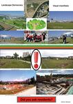
Step 1: Your Landscape Democracy Manifestoes
-
 Mira's Manifesto
 -
 Edvin's manifesto
 -
 Haroldo's manifesto
 -
 Melanie's manifesto
 -
 Sobhan's Manifesto


Step 2: Define your readings
- Please add your readings selection for the terminology exercise before April 12:
A: Landscape and Democracy - Mapping the Terrain
- Mira Hennerkes
- European Charter on Participatory Democracy
Landscape Concepts:
- Sobhan Saadat
- Lynch, Kevin. (1960): The Image of the City
B: Concepts of Participation
- Edvin Memić
- Day, Christopher (2002): Consensus Design, Architectural Press
C: Community and Identity
- Melanie Schnürer
- Welk Von Mossner, Alexa (2014): Cinematic Landscapes
D: Designing
- Mira Hennerkes
- Hester, Randolph (1995) Life, Liberty and the Pursuit of Sustainable Happiness
E: Communicating a Vision
- Melanie Schnürer
- Storytelling example from the Scottish Islands
Steps 3 and 4: Concepts Selection and definition
- Each group member selects three relevant concepts derived from his/her readings and synthesize them/publish them on the wiki by April 30, 2017
- Group members reflect within their groups and define their chosen concepts into a shared definition to be posted on the wiki by May 10, 2017.
- Other group members will be able to comment on the definitions until May 20, 2017
Concepts and definitions
Author 1: Sobhan Saadat
- Legibility of City (Lynch, Kevin. (1960): The Image of the City, Cambridge, Mass.: MIT Press)
- A legible city would be one whose districts or landmarks or pathways are easily identifiable and are easily grouped into an overall pattern
- Environmental Images (Lynch, Kevin. (1960): The Image of the City, Cambridge, Mass.: MIT Press)
- Environmental images are the result of a two-way process between the observer and his environment suggests distractions and relations, and endows with meaning what he sees. The image so developed now limits and emphasizes what is seen, while the image itself is being tested against the filtered perceptual input in a constant interacting process. Thus the image of a given reality may vary significantly between different observers.
- Five Elements of City Image (Lynch, Kevin. (1960): The Image of the City, Cambridge, Mass.: MIT Press)
- The city can be simplified into its five basic elements: 1.Paths 2.Edges 3.Districts 4.Nodes 5.Landmarks
-PATHS are the roads which runs throughout the city mesh. It can be resembled to channels for watching a movies, a user can choose between different alternative of paths. -EDGES are everywhere in a city it can be a narrow stream beside a street or be the set of buildings that define fringe of a neighborhood. Edges are the boundaries of different kinds inside a city either in small or large scale. -DISTRICTS are clusters of similar blocks which are easily distinguishable from the rest of the clusters. Within the same district several common characteristics are dominant and observable. Districts can form in any shape in the city mesh which are recognizable with their specific Edges or boundaries from the other Districts. -NODES are the point references in the city which are penetrable. A square can be a node in a city which is used by users and one can enter to or exit from. A motorway intersection can also be a node in city, where two streets (paths) meet each other. -LANDMARKS are also point references in a city however, they are not penetrable. Landmarks are addressable. A monument for instance in a city can be a landmark which plays a significant role in being addressable of a territory which is itself an extensive topic.
Author 2: Edvin Memić
- Concept 1
- If several people have different opinions about something, does that mean that they need to seek a compromise, although the compromise is kind of giving up from own opinions. But if it will lead to a better situation in general, this is not a bad solution. (Day, Christopher (2002): Consensus Design, Architectural Press)
- Concept 2
- Voting is not good because of the fact that majority opinion is used, while minority opinion is rejected, although sometimes it may be better. (Day, Christopher (2002): Consensus Design, Architectural Press)
- Concept 3
- Consensus is best for making decisions. When a consensus is reached, the decision is made step by step, the opinion of individuals is reconsidered, and the best solution for the group is accepted. Although it takes more time. (Day, Christopher (2002): Consensus Design, Architectural Press)
Author 3: Mira
- European Charter on Participatory Democracy in Spatial Planning Processes
- Recall and call for values and tasks that are associated with democratic participation
- Definition of a 'common ground' and reinvigorating a 'democratic ethos'
- Framework, that promote the visibility, recognition and importance of the social role in planning processes through the following topics: Aim, Involvement and Representation, Information and Education, Operational Rules, Access and Expression, Continuity, Relevant Experts, Decision-making Authority, Monitoring of the implementation of the Charter, Awards, Relationship with other instruments
- Considering participation of individuals in public life, local social stability by democratic legitimacy
- Hester, Randolph (1995): Life, Liberty and the Pursuit of Sustainable Happiness
- "Use of non-renewable resources result in short-term freedom but long-term consequences"
- To provide resources (e.g. food), community-based living forms are no longer needed
- Individually shaped ways-of-life, individual security, independent identities
- Freedom from environmental constraints, no connection between environmental issues and daily life to secure livelihood
- Anomie: weak community-based standards/ rules/ guidelines -- State of confusion about how to act towards (sustainable) communities and landscapes
- Community and Environment: new relationships with both are needed
- Guideline on how to change the habit, necessary to break the negative cycle of decreasing sustainability and disorientation
- Three distinctive traits: enabling form, resilient form, impelling form
- Enabling form: Principles can help design enabling places
- Resilient form: Increase of resilience to become sustainable and free from bioregional limits; repair natural systems that has been stressed and mix land use
- Impelling form: increasingly difficult to address sustainability through national mandate - choice impels, priority framework, continuous experiments, active responsible ("not in my backyard")
- "Use of non-renewable resources result in short-term freedom but long-term consequences"
Author 4: Melanie Schnürer
- Essential features (Welk Von Mossner, Alexa (2014): Cinematic Landscapes, In: Topos, No. 88, 2014.)
- Essential features of a narrative film are, besides the natural and built environment, also the authenticity of the landscape, which plays an active role in a fiction film. "Beasts of the Southern Wild" (a film by Benh Zeitlin) is a good example for such a cinematic narrative.
- The space (Welk Von Mossner, Alexa (2014): Cinematic Landscapes, In: Topos, No. 88, 2014.)
- The space, which represents the cinematic environment, is the space in which the action takes place; in the film language this is called "setting". This room has to be carefully constructed, and for the cinematic environment all kinds of tricks are used.
- Realization of a visually spectacular backdrop (Welk Von Mossner, Alexa (2014): Cinematic Landscapes, In: Topos, No. 88, 2014.)
- In the past, a landscape was created on a soundstage of a film studio for the realization of a visually spectacular backdrop for a narrative; today such scenes are replaced by computer animations. The actors shoot in front of a green screen.
- City and urban design framework (Storytelling example from the Scottish Islands)
- For cities, it is important to gain an overview by creating an urban design framework that can be used to coordinate the existing projects and then use this as the basis for future development documents and master plans for the individual sites.
- Working with other studies and initiatives (Storytelling example from the Scottish Islands)
- WMUDs, which had created the urban design framework, worked in parallel with other studies and initiatives (e.g. Townscape Heritage Initiative (THI), Pierhead Project) to submit a proposal to the city on how to improve the contrasts between the individual elements.
- Future of the city (Storytelling example from the Scottish Islands)
- In order to obtain a good result, for the future of the city, one must think about various questions, e.g. How does the city look like in a few years?; How can other districts be integrated? ... Such questions are answered either positively or negatively. Sometimes a compromise must be sought for some questions.
Step 5: Reflection
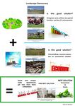
The mainstream of the all thoughts and concepts in this context are directly or indirectly orienting around including others in the design. The Democratic participation of the people, organizations and communities who are sharing a landscape is crucial for a better, inclusive and divergent implications. However, it is an inherent challenge to gather all the key players on the same table and meet their interests. In this regard, some instructions must be taken into account in order to avoid any deprivation. For instance, a new approach other than voting is needed to consider the minorities as well as majorities in the design; an innovative approach like workshop which calls everyone's idea in the procedure. Apart from that, throughout the planning and design procedure, the current situation should be considered but more importantly the "future applicability" of it should be seen. In order to obtain a good result, for the future of the city, one must think about various questions, e.g. How does the city look like in a few years?; How can other districts be integrated? ... Such questions are answered either positively or negatively. Sometimes a compromise must be sought for some questions. Nevertheless, it is always a threat to mislead from the main direction of the design or planning, due to the vast number of criteria or exceptions from many actors. Thus, it is a good idea to keep the framework within a balance between every single categorized factors, from agendas and interests to the actors.
Step 6: Revised manifestoes
- please look again at your initial manifestoes and update them with any new aspects/prespectives you have taken up during this seminar
-
 Mira's updated manifesto
 -
 Edvin's updated manifesto
 -
xy's updated manifesto
-
 Melanie's updated manifesto
 -
 Sobhan's updated manifesto


Assignment 2 - Your Landscape Symbols
- You can read more details about this assignment here
Landscape Symbols Sobhan Saadat
-
 The topography of the zone is very especial, where both lower level of stream and high level of the mountains run alongside eachother. The mountain provides an urban opportunity of hiking for the citizens. However, it is noteworthy that the city in general is a large plain between some of the lower chain of well-known Zagros mauntain stretching from north-west of country to the south-west, 29°39'22.6"N 52°29'53.3"E.
 -
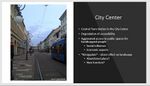
 Chamran linear park is one of the most important spots in the city Shiraz and in my opinion is the most noticeable landscape symbol in the city. Not only in terms of size but also in terms of variety of nature and non-natural elements it encompasses. A very unique combination of stream with gardens and trees on one side and the mountain and buildings along the linear park on the other side, 29°37'59.6"N 52°29'29.5"E.
 -
 It makes the place one of the zones to breathe fresh air and picnic at the weekends. Also provides many activates within its range that hardly ever dim around the clock, especially when the weather is warm. In addition, the road with the same name carries good number of vehicles from the city center to the northern part of the city which has become growingly more popular to inhabit. Although the last trait might be considered as a disadvantage, it is inevitable that is a factor in the dynamic quality of the zone, 29°39'46.9"N 52°29'16.4"E.
 -
 However, recently due to the new phase of constructions and also little amount of precipitations quality of this valuable urban area has diminished. There are many zones in Shiraz that are disadvantaged from the same trend and unfortunately the authorities are doing the least to encounter the damages to the landscape of the city which ironically is very fragile and vulnerable, 29°39'10.5"N 52°30'03.5"E.


Landscape Symbols Edvin Memić
-
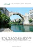 Old Bridge in Mostar over the Neretva River is a UNESCO World hertage and when is built, it was the largest arch structure in the world. Sulejman the Magnificent ordered to build in 1566, and the architect was Mimar Hajrudin. Connects two parts of the city, and symbolizes connection, historical, architecture, culturally. Geo-location: 43° 20′ 13.57″ N, 17° 48′ 53.39″ E
 -
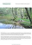 Wellspring Bosnia is a source in central Bosnia and Herzegovina. The source of the river Bosna, and one of most famous landmarks of Bosnia and Herzegovina. Bosnia Wellspring located on the ouskirts of Sarajevo. One of the most famous parts of the natural beauty of the region. It is famous tourist attraction and it’s a symbol historical, culturally, recreation, greenery. Geo-location: 43°49'10"N 18°16'10"E
 -
 Bijambare are law protected area by the Sarajevo Canton. It is located on the main road Sarajevo - Tuzla. Spreads on 370 hectares and includes coniferous forests, pastures, two small rivers, and six caves. The largest cave is called Main Bijambare Cave. In one of the caves discovered the remains of the cave man, a tool a stone processing, and remnants of animals. Symbol is recreation, history, clean air. Geo-location: 44° 4′ 48.17″ N, 18° 30′ 55.1″ E
 -
 Place name: Alley of ambassadors in Sarajevo. The trees are planted on both sides of the street, the street is used exclusively as a pedestrian zone. This is a friendly relationship between the countries, Bosnia and Herzegovina and state accredited ambassador. Wood represents life, something that is growing. It is a symbol connecting, walking, memories. Geo-location: 43°51'29.1"N 18°26'37.1"E


Landscape Symbols Mira
-
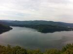 The picture shows the Edersee, one of the largest water reservoirs in Germany. The reservoir is located in the state of Hessen, about one hour from Kassel. The construction of the Edersee Dam took place around 1910. Three villages in the former valley vansihed under the water surface and about 900 people has been relocated for the project (51 11 15N 9 3 29E).
 -
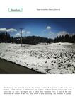
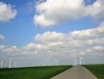 Renewable Energy impact on landscapes. Somewhere between the villages Dalheim and Marsberg in Germany (51 37 2N 8 53 41E).


Landscape Symbols Melanie Schnürer
-
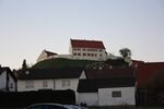 Castle Altenberg was mentioned for the first time more than 600 years ago. It was destroyed and rebuilt several times. Under the rule of Franz Ferdinand von Syrgenstein, the present castle was built in 1693. In 1986, Princess Clothilde of Liechtenstein acquired Schloss Altenberg (Geo location: 48°39'29"N; 10°18'11"E)
 -
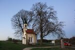 Chapel Maria Schnee is located in Staufen, Bavaria. The Catholic Chapel Maria Schnee was built in 1895 in the style of Neo-Gothic as a thank-you for the accident-free construction of the parish church of St. Martin, which is also located in Staufen (Geo location: 48°39'57"N; 10°17'9"E)
 -
 The manor is located in Stetten ob Lontal. Since 1992 a separate knighthood exists in Stetten. This knighthood on this manor organized each year (since 2011) a medieval market with Knight-games (Geo location: 48°33'8"N; 10°12'24"E)


Landscape Symbols Haroldo
-
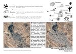
 The city of Palmas is the last planned capital in the XX century and was designed to be the capital of Tocantins, the newest state of Brazil. Palmas was designed between two landmarks, one natural (Carmo's Sierra) and the other artificial (Lajeado's Lake). The city has lots of other landmarks, such as the Girassol's Square (2nd biggest square in the world) and the Aragauia Palace. The square is located in the meeting point of the two main axial avenues of Palmas.

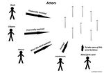
Assignment 3 - Role Play on Landscape Democracy "movers and shakers"
- You can read more details about this assignment here
Assignment 4 - Your Landscape Democracy Challenge
- You can read more details about this assignment here
- Each group member will specify a landscape democracy challenge in his/her environment
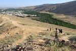
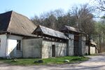
Landscape Democracy Challenge; Sobhan Saadat
- Burning Gardens
-
 This is a very compatible and up to date issue in the city which has raised many controversial debates between authorities and people
 -
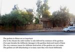
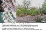 The debate is mainly over gardens in the city which play a significant role in well-being of the city. As the climate is defined dry and warm, these gardens are refreshing the air and working as the lungs of the body of the city. Hence not only preservation but also expansion of them seems to be the priority. However, over decades the reverse process has been going on and caused the green areas perish through the city. However, the expenses for preservation of the gardens are extremely high and authorities not only provide subsidies but also limit the resources of that agenda such as forbidding water extraction from ground. Meanwhile, authorities blame the owners for being complacent and damaging the whole city so they sometimes arrogate the lands. Although in some cases the owners let the gardens to dehydrate deliberately and then make money by building it up, it is not true always. But the question is whether such infractions are because the owners see their loss in preserving the garden while a lot of profit in destroying them? Perhaps by an appropriate policy authorities can encourage the owners to preserve them? Secondly, the question is whether the gardens belong to the privates or should it be taken as a public property as it is so important for the whole city?
 -
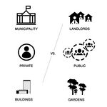 The actors of the Challenge are mainly the citizens and the Authorities. While Municipality blame landlords for their ignorance approach toward preservation of gardens, Landlords are not satisfied by any support from public sector to be able to preserve the green areas


Your references:
- Internal reports and Newspapers/Websites
- Personal Observation
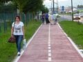
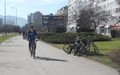
Landscape Democracy Challenge: Edvin Memić
- Bicycle path
-
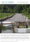
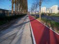 Bike path in Sarajevo is one of the major projects started recently, which runs through several municipalities. This is the first bike path in Bosnia and Herzegovina, which was built for this purpose, and which goes through the city.
 -
 Bike path has certain disadvantages, especially significant that as in some sections is not well built, or there is not enough space for pedestrians.
 -
 There is no bike paths for the whole city.
 -
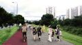 Participants of this stock are mostly cyclists, while in some places share part with pedestrians, which means they must be careful. Although this trail is not designed for professional driving, but still part of the bicycle routes that is built is used often.


Your references:
- http://girodisarajevo.ba/2015/04/osvrt-na-izgradnju-biciklisticke-staze-u-sarajevu/
- https://www.klix.ba/vijesti/bih/grad-sarajevo-biciklisticka-staza-ce-biti-po-evropskim-standardima/141028083
Landscape Democracy Challenge Mira
- Public transport in Kassel
-
 Currently, public transport is a topic with high relevance in Kassel. The public transport company worked out modification plans for the public systems.
 -
 The consequence is a less frequency and accessability.


Your references: www.kvg.de
Landscape Democracy Challenge Melanie Schnürer
- Wind turbines don't produce enough energy
-
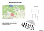 I select this case, because it's near my homevillage and the wind turbines can be seen from a distance
 -
 The issue is, that many citizen don't want this wind turbines, but they want cheap energy
 -
 The conflict is, that the wind turbines don't produce enough energy to store in households
 -
 The actors are the citizen, the bank, the mayor, the parliament and the wind farm carer


Your references:
- http://gegenwind-starnberg.de/tag/zoeschingen/
- http://www.br.de/nachrichten/schwaben/inhalt/windraeder-zoeschingen-108.html
Landscape Democracy Challenge 5
- Give a title to your challenge
-
caption: why did you select this case?
-
caption: what is the issue/conflict (1)
-
caption: what is the issue/conflict (2)
-
caption: who are the actors?
Your references:
- ...
- ...
Assignment 5 - Your Democratic Change Process
- You can read more details about this assignment here
- After documenting and reflecting on your challenges you will continue jointly with one of these challenges and design a democratic change process
Your Democratic Change Process
- Palmas BRT
-
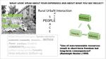
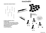
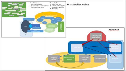 Our power map identifyed who is affected by the challenge and who is influencing it. They project is critized by various ways. Due to the top-down planning process, the local communities and environmental groups had very little power to participate in the planning process. Further, these groups act quite unorganized. The change occured with start of the investigations: The investigators and authorities blocked the whole project to move on due to financial irregularities. The major is fighting against this. At the beginning of the project, the planning process was organized top-down by the project-side. Currently, the "top-down" is ruled by the law
 -
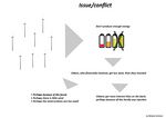
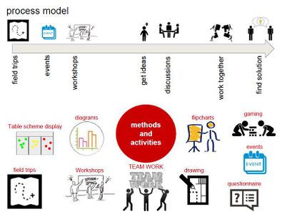 Look at the various methods and tools available and think how they can be applied creatively. Think about the needs of different stakeholder groups - you may need a methodical mix to address them all. Illustrate graphically how these methods/tools might be applied in a short, medium and long-term perspective.
 -
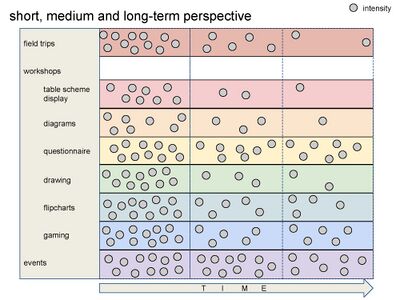 A scenario illustrating how these tools can be applied within a short, medium and long term perspective involving the groups you want to address, this should include a process timeline


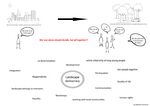
Reflection
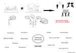
Our ideas based strongly on theoretical frameworks with two focus questions:
- How to involve people?
- How to shape the process to find a consens?
While the powermap is based on a classical strakeholder analysis, the finding of the further methods and about the timeframe was more difficult and group discussions took place several times because of the varity of possible tools/methods. We formed two categories ("Prorities" and "Still in change") to apply the identifyed methods. Especially the time plays a crucial role in our challenge. Summarizing, the varity of planning tools and methods we associate with "landscape and democracy" increased and we varifyed, that simple methods (like walks) can have great and challenging effects
Your references
- Powermap: https://www.youtube.com/watch?v=VkTgaUGlMZQ&t=24s, https://www.youtube.com/watch?v=W0EU2C2AjRA
- LED-lectures