LED Online Seminar 2018 - Working Group 1
--> Back to working group overview
Dear working group members. This is your group page and you will be completing the template gradually as we move through the seminar. Good luck and enjoy your collaboration!
Assignment 1 - Reading and Synthesizing Core Terminology
- You can read more details about this assignment here
- Readings are accessible via the resources page
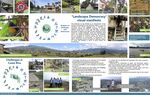
Step 1: Your Landscape Democracy Manifestoes
-
 Rashad's manifesto
 -
 Irma's manifesto
 -
 Abhishek's manifesto
 -
 Laura's manifesto
 -
 Salma's manifesto


Step 2: Define your readings
- Please add your readings selection for the terminology exercise before April 18:
A: Landscape and Democracy
Kucan, Ana (2007). Constructing Landscape Conceptions (Salma Malak Bennasser)
Burckhardt, Lucius (1979): Why is landscape beautiful? in: Fezer/Schmitz (Eds.) Rethinking Man-made Environments (2012) (Laura Chaverri Flores)
Culture and changing landscape structure.pdf (Abhishek Passan)
Strategic Environmental Assessment Directive  (Rashad Gasimov)
Directive on public access to environmental information (Rashad Gasimov)
B: Concepts of Participation
Day, Christopher (2002): Consensus Design, Architectural Press (Irma Karic)
Sanoff, Henry (2014): Multiple Views of Participatory Design (Salma Malak Bennasser)
Hester, Randolph (2012): Evaluating Community Design, Landscape Journal (Laura Chaverri Flores)
Arnstein, Sherry R. - A ladder of citizen participation.pdf (Abhishek Passan)
Gaventa, John: The Powerful, the Powerless, and the Experts (Rashad Gasimov)
C: Community and Identity
Welk Von Mossner, Alexa (2014): Cinematic Landscapes, In: Topos, No. 88, 2014 (Irma Karic)
Right to the city.pdf (Abhishek Passan)
Woodend, Lorayne (2013): A Study into the Practice of Machizukuri  (Rashad Gasimov)
D: Designing
Smith, Nicola Dawn(2012): Design Charrette: A Vehicle for Consultation or Collaboration (Irma Karic)
Hester, Randolph: Democratic Drawing - Techniques for Participatory Design (Salma Malak Bennasser)
Hester, Randolph: Life, Liberty and the Pursuit of Sustainable Happiness (Laura Chaverri Flores)
Massachusetts Institute of Technology (2013): Places in the Making: How Placemaking Builds Places and Communities (Rashad Gasimov)
E: Communicating a Vision
Steps 3 and 4: Concepts Selection and definition
- Each group member selects three relevant concepts derived from his/her readings and synthesize them/publish them on the wiki by May 9, 2018
- Group members reflect within their groups and define their chosen concepts into a shared definition to be posted on the wiki by June 6, 2018.
- Other group members will be able to comment on the definitions until June 12, 2018
- Each group will also report on their process to come to a set of shared definitions of key landscape democracy concepts on the wiki documentation until June 20, 2018
Concepts and definitions
Author 1: Rashad Gasimov
- Powerful Powerless (Gaventa, John: The Powerful, the Powerless, and the Experts)
With rise of services economy the products are intangible becoming now more valuable. Knowledge is the most precious development that human being reached. Even the limits of the knowledge are not defined yet. That knowledge is distributed as a good/service and has an economical value. This economical value is making knowledge holders more powerful.
- Public access to environmental data (European Union Law)
Having access to any sort of data in equal rights bringing people together and raising the awareness to the topic. It is a basic right of accessing the information. In this light environmental data becoming more important to raise awareness. So in behalf of public governments are producing the data and it should be shared with the public in easy way that can anyone access this info and use it.
- Places in the making (Massachusetts Institute of Technology (2013): Places in the Making: How Placemaking Builds Places and Communities )
It is now more and more are questioning the traditional approach of planning as an instrument for neighborhood, city or region. Traditionally giving less importance to the people or users, planning is lacking the design or predictions of inter personal relationships. Thus bringing to revise the planning according to these relationships in every possible sequence. Places in the making is focusing on these relationships and bringing them into the action and planning.
Author 2: Irma Karic
- Day, Christopher (2002): Consensus Design - When it comes to choosing the proper option for certain design, 'voting' is not the option because some people may agree on it while the rest may not. During the design process the emotions should be included so that common ground between participants can be set. In that sense, even being on the opposite sides of the road, people can find 'a middle' or compromise on which greater majority can agree upon.
- Welk Von Mossner, Alexa (2014): Cinematic Landscapes - A place we live in is not only characterized by its physical features but certain feelings that are evoked in people's minds while being at or seeing certain place. The cinematic landscapes are usually chosen to support the narrative of the story not just by its physical appearance but by the feeling that they may evoke.
- Smith, Nicola Dawn(2012): Design Charrette: A Vehicle for Consultation or Collaboration - Charrette represents sets of tools that are used in an early stage of design process where main stakeholders are brought together not for consultation but for co-collaboration speeding up the entire design process with interactive brainstorming and decision making.
Author 3: Abhishek Passan
- Culture and Changing landscape Structure; As depicted by the name it establishes a relationship between the cultural development and landscape ecology. It establishes to have various experiments also extending the scope to work over the human level as well as having multiple disciplines incorporated.
- Arnstein Ladder of Citizen Partnership gives an introduction over the form of citizen participation when making claims about the power and also evaluates the existing level of power available with the community at varied levels. It just gives a small glimpse for some levels and also establishes the base for the other levels which are not listed.
- Right to the city, David Harvey; It establishes a relationship between the level of urbanization or the changes in the development process with the concept of changing individuals identity. Both the systems are directly related and also the extent of power plays a crucial factor in deciding the level of development.
Author 4: Laura Chaverri Flores
- “Landscape is a construct” (Fezer J., Schmitz M. (2012) Lucius Burckhardt Writings): Landscape is to be found in the mind’s eye of those doing the looking; influenced by the educational background and not in a environmental phenomena. Landscape consists of many different layers: the visual layer of colors; a layer comprising the first hints of natural or technological production infrastructures; and a layer in which social aspects and hence, also a temporal dimension can be identified.
- Transactive design (Hester, Randolph, 2012, Evaluating Community Design) (Friedmann 1973; Sano 2000): Concept that Friedmann developed, that includes mutual learning between designer and users in the workshops and participatory design. The informed exchange is possible when the designer achieve to walk in the shoes of the users and teach the users to walk in the shoes of the designer. Transactive planner/designer play many roles and “has the responsibility to challenge values just as he or she introduces best practices to make innovative ideas reality”(p.139).
- Resilient Form (Hester, Randolph): For Randolph Hester the design of the sustainable city must be guided by: enabling form, resilient form and impelling form. The Resilient Form can “repair natural systems that have been stressed to the point of dysfunction and create new forms of habitation that respond joyfully to these limits rather than simply being constrained by them” (p.10).
Author 5: Salma Malak Bennasser
- Landscape identity: It is the concept of the identification to landscapes. It is a social construct, that is changeable and evolving. It is formed on the basis of the physical reality but transformed by the processes of social communication that help construct a social conception of the landscapes using the social system of values. Kucan, Ana (2007)
- Representative representation: It is the way drawing is used in order to communicate with communities as honestly and realistically as possible instead of using an idealized misleading picture of the future landscape. In participatory work, drawing is used to collectively visualize, communicate and design not to persuade. Hester, Randolph
- Collective intelligence: It is a concept that groups, through the process of interaction, are able to come up with a more insightful and powerful solution that the sum of individual perspectives. Sanoff, Henry (2014)
Step 5: Reflection
Step 6: Revised manifestoes
- please look again at your initial manifestoes and update them with any new aspects/prespectives you have taken up during this seminar
-
 Author1's updated manifesto
 -
Author2's updated manifesto
-
Author3's updated manifesto
-
Author4's updated manifesto
-
Author5's updated manifesto

Assignment 2 - Your Landscape Symbols
- You can read more details about this assignment here
Landscape Symbols Author 1: Rashad Gasimov
-
 Zaha Hadid building of Haydar Aliyev erected in 2012 in Baku/Azerbaijan to symbolize the development of the city and its built nature.
 -
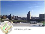 Building looking to cityscape.
 -
 Cityscape looking to building.


Landscape Symbols Author 2: Irma Karic
-
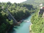 The important landscape symbol of small town Jablanica (B&H) with great historical value reminding on one of the most famous battles from WWII - Battle of Neretva. The bridge was destroyed three times: once as a ruse, then in an actual attack while Partisans were defending themselves from the Axis forces coming from the eastern bank of Neretva river, and finally for the movie. The addition to this historical remaining is Neretva river, the natural landmark of Herzegovina.
 -
 Alipašino Polje is a modernistic planned neighborhood in 1970's in Sarajevo. It is one of the most populated areas in the city. Today it doesn't only represents housing but also a reminder of former Yugoslavia and it's Socialism.
 -
 Center of the old town of Sarajevo - Baščaršija, is a monument of historical period of Bosnia being part of Ottoman Empire. This part of the city is known as commercial area where people would/are selling their hand-made products. It is one of the most important touristic attractions in the city. Baščaršija is symbol of time, oriental architecture and preserved traditional crafts.


Landscape Symbols Auther 3: Abhishek Passan
-
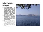
 Lake Pichola, Udaipur is an artificial lake constructed in 1362 AD. It is one of the contiguous lake for Udaipur city as it was meant to meet the water for varied uses and was constructed by creating dams so as to store the rain water as to majorly serve the drinking needs as well as for the irrigation purpose. It also has four islands to it with varied landuses to them. But the current scenario has totally changed as now it serves as a commercial and recreational area for the users and is a major tourist destination. The environmental conditions of the lake are in grave danger because of which deterioration has been caused to the aquatic life as well as to the quality of water. It not only represents to the landscape symbol but is a prime node today as well as in earlier days was used by the Kings for recreational purpose thus granting it a historic as well as religiously important.Co-ordinates : 24° 34′ 19.2″ N, 73° 40′ 44.4″ E
 -
 City Palace, Udaipur is a palace complex and was constructed in 1553 with a time span of around 400 Years. It is a true symbol of power and dominance as it depicts the heritage, tradition and culture prevailing in the area. Now, one of the major tourist destinations used to be the residence of the royal family as well as is a symbol of strength and flamboyant environment for the city.Co-ordiantes: 24.576°N 73.683°E
 -
 Skyline, Udaipur. It depicts the natural undulations in the city surrounded by many landscape symbols such as hills, lakes and many other natural and man-made features thus making it a vibrant city and also imparting heritage value to the place. These features are the key landscape symbols to make the area more vibrant and habitable.


Landscape Symbols Author 4: Laura Chaverri Flores
-
 The U-suré, conical house or cosmic house, is impregnated with symbolism and has faced different use changes over time. Before the arrival of Europeans in Costa Rica was used as a traditional house. The roof is a large cone that represents a celestial vault. After independence, the Ministry of Health prohibited the Indigenous people to use their traditional house as a home, they were inserting western houses in these communities. In this way, the U-suré became a traditional and sacred space and a house of culture. It is believed that there is another identical cone that grows below the ground, where the 4 virtual underworlds are located. Suita palm is used for it construction so the house is biodegradable and every 12 years is rebuilt in a collective ceremony, at the end of the construction there take place a community celebration. There is at least one U-suré in any bribri community. The picture shows Cachabri´s U-suré cultural house, in Talamanca at the east of the country. Today this symbol means identity that reminds us of a large portion of our indigenous history that is constantly invisible from Eurocentric hegemonic discourses.
 -
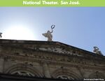 The construction of the National Theater began in 1891 and was inaugurated in 1897, in San José city. It was promoted by the coffee oligarchy that had political power at that time. The intention was to have a European-style theater that would serve as amusement place for the bourgeoisie of the time. At that time, a series of national buildings were created to build a nationalist identity based on the Europeanization of the Costa Rican people. This is why the National Theater style is german neo-clasical. There were exclusively Europeans shows, such as operas and classical music concerts. At that time, the theater was the most expensive and hierarchical building in San José and was a symbol of "culture" and development. Today this building does not stop having iconic prominence. Its use has been democratized promoting free shows and diverse cultural activities such as popular dance and Costa Rican music. However, it remains a symbol of power that many Costa Ricans with low incomes do not know inside. I think the symbolic hierarchy can be very understandable to any citizen who knows Western culture.
 -
 Guayabo National Monument was an ancient indigenous city populated from 1000 before Christ to 1400 after Christ, located in Turrialba. According to the latest research the city was abandoned before the arrival of the Spaniards. The city was strategically located in a Valley, between two rivers with a visual finish to another very important natural symbol, the Turrialba volcano. Guayabo was buried for a long time, until several archaeologists rediscovered it. In 1973 it began with the recovery of the site that was declared, at that time, National Monument, becoming the largest archaeological site in the country. In 2009 it was declared a World Heritage Site due to the complexity of its aqueducts. In addition, nowadays a remnant of evergreen pre-montane rainforest is protected. This site is still part of the identity of the Costa Rican and although it is no longer used as a city but as a place to visit, it can help us understand how a pre-Columbian city worked in our territory. Although today conical houses cannot be seen because of their biodegradable condition, it is possible to imagine them and go back in time to visualize the city in its splendor.


Landscape Symbols Author 5: Salma Malak Bennasser
-
![Agadir Oufela:Hill with an inscription using painted stones meaning:«God, Country, King». The inscription found in many other hills around the country, represents a symbol of solidarity between the king and the people under one religion.Its summit is occupied by the ruins of the ancient fortress which was build in 1572 and that was destroyed due to the earthquake in 1960. The hill holds the original name and the history of the city « Agadir ». [1]](/images/thumb/8/86/Agadir_oufela.jpg/150px-Agadir_oufela.jpg) Agadir Oufela:Hill with an inscription using painted stones meaning:«God, Country, King». The inscription found in many other hills around the country, represents a symbol of solidarity between the king and the people under one religion.Its summit is occupied by the ruins of the ancient fortress which was build in 1572 and that was destroyed due to the earthquake in 1960. The hill holds the original name and the history of the city « Agadir ». [1]
Agadir Oufela:Hill with an inscription using painted stones meaning:«God, Country, King». The inscription found in many other hills around the country, represents a symbol of solidarity between the king and the people under one religion.Its summit is occupied by the ruins of the ancient fortress which was build in 1572 and that was destroyed due to the earthquake in 1960. The hill holds the original name and the history of the city « Agadir ». [1] -
![The wall of commemoration or remembrance: Wall ingraved in Arabic calligraphy with a quote from King Mohammad V:«Fate may have decided to destroy Agadir, but its reconstruction depends on our faith and will». It is dedicated to the victims of the 1960 earthquake. While the clear message of the quote is the faith and determination to rebuild the city but also the solidarity with the families of the victims, the wall symbolizes an important religious belief of most Moroccan people, which is to accept destiny and never lose hope as things get better after difficult times.[2]](/images/thumb/e/e1/The_wall_of_commemoration.jpg/150px-The_wall_of_commemoration.jpg) The wall of commemoration or remembrance: Wall ingraved in Arabic calligraphy with a quote from King Mohammad V:«Fate may have decided to destroy Agadir, but its reconstruction depends on our faith and will». It is dedicated to the victims of the 1960 earthquake. While the clear message of the quote is the faith and determination to rebuild the city but also the solidarity with the families of the victims, the wall symbolizes an important religious belief of most Moroccan people, which is to accept destiny and never lose hope as things get better after difficult times.[2]
The wall of commemoration or remembrance: Wall ingraved in Arabic calligraphy with a quote from King Mohammad V:«Fate may have decided to destroy Agadir, but its reconstruction depends on our faith and will». It is dedicated to the victims of the 1960 earthquake. While the clear message of the quote is the faith and determination to rebuild the city but also the solidarity with the families of the victims, the wall symbolizes an important religious belief of most Moroccan people, which is to accept destiny and never lose hope as things get better after difficult times.[2] -
![Argan tree: An endemic tree to Morocco growing between safi and the fringes of the Sahara. It is a centenary tree that can live up to 200 years. It can grow in extreme conditions of soil and drought and it help fight against soil erosion and desertification. Argan oil, known as « the Moroccan oil » outside of the country, is extracted from the kernel of its fruit and is used for its cosmetic propreties. It is used to combat the aging and the drying of the skin, for softer and stronger hair and to strengthen breaking nails. It is considered the only source of income for some people living in remote and arid areas. For those reasons it can be considered the national symbol of resistance and strength as well as the symbol of youth and beauty. [3]](/images/thumb/e/ef/Argania_spinosa.jpg/150px-Argania_spinosa.jpg) Argan tree: An endemic tree to Morocco growing between safi and the fringes of the Sahara. It is a centenary tree that can live up to 200 years. It can grow in extreme conditions of soil and drought and it help fight against soil erosion and desertification. Argan oil, known as « the Moroccan oil » outside of the country, is extracted from the kernel of its fruit and is used for its cosmetic propreties. It is used to combat the aging and the drying of the skin, for softer and stronger hair and to strengthen breaking nails. It is considered the only source of income for some people living in remote and arid areas. For those reasons it can be considered the national symbol of resistance and strength as well as the symbol of youth and beauty. [3]
Argan tree: An endemic tree to Morocco growing between safi and the fringes of the Sahara. It is a centenary tree that can live up to 200 years. It can grow in extreme conditions of soil and drought and it help fight against soil erosion and desertification. Argan oil, known as « the Moroccan oil » outside of the country, is extracted from the kernel of its fruit and is used for its cosmetic propreties. It is used to combat the aging and the drying of the skin, for softer and stronger hair and to strengthen breaking nails. It is considered the only source of income for some people living in remote and arid areas. For those reasons it can be considered the national symbol of resistance and strength as well as the symbol of youth and beauty. [3]
![Agadir Oufela:Hill with an inscription using painted stones meaning:«God, Country, King». The inscription found in many other hills around the country, represents a symbol of solidarity between the king and the people under one religion.Its summit is occupied by the ruins of the ancient fortress which was build in 1572 and that was destroyed due to the earthquake in 1960. The hill holds the original name and the history of the city « Agadir ». [1]](/index.php?title=File:Agadir_oufela.jpg)
![The wall of commemoration or remembrance: Wall ingraved in Arabic calligraphy with a quote from King Mohammad V:«Fate may have decided to destroy Agadir, but its reconstruction depends on our faith and will». It is dedicated to the victims of the 1960 earthquake. While the clear message of the quote is the faith and determination to rebuild the city but also the solidarity with the families of the victims, the wall symbolizes an important religious belief of most Moroccan people, which is to accept destiny and never lose hope as things get better after difficult times.[2]](/index.php?title=File:The_wall_of_commemoration.jpg)
![Argan tree: An endemic tree to Morocco growing between safi and the fringes of the Sahara. It is a centenary tree that can live up to 200 years. It can grow in extreme conditions of soil and drought and it help fight against soil erosion and desertification. Argan oil, known as « the Moroccan oil » outside of the country, is extracted from the kernel of its fruit and is used for its cosmetic propreties. It is used to combat the aging and the drying of the skin, for softer and stronger hair and to strengthen breaking nails. It is considered the only source of income for some people living in remote and arid areas. For those reasons it can be considered the national symbol of resistance and strength as well as the symbol of youth and beauty. [3]](/index.php?title=File:Argania_spinosa.jpg)
Assignment 3 - Role Play on Landscape Democracy "movers and shakers"
- You can read more details about this assignment here
Irma Karic: Robert Jungk (Zukunftswerkstatt) Laura Chaverri: Jan Gehl
Assignment 4 - Your Landscape Democracy Challenge
- You can read more details about this assignment here
- Each group member will specify a landscape democracy challenge in his/her environment
- Each Landscape Democracy Challenge should be linked to two or three of UN's 17 sustainable development Goals
Landscape Democracy Challenge 1
- Give a title to your challenge
-
caption: why did you select this case?
-
caption: what is the issue/conflict (1)
-
caption: what is the issue/conflict (2)
-
caption: who are the actors?
-
caption: UN's Sustainable Development Goal?
-
caption: UN's Sustainable Development Goal?
Your references:
- ...
- ...
Landscape Democracy Challenge 2 Irma Karic
- Tibra Pacific, Sarajevo-'How not to build'
-
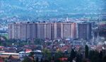 Sarajevo became large construction site where buildings are rising regardless urbanistic plan restrictions and basic human needs for living.Cheaper living spaces with low living standards offered not only affect people living there but generally affect the entire image of the city while contributing to already developed pollution challenges that the city faces. One of the neighborhoods that serves as an amazing example of how not to build is Tibra Pacific residential neighborhood.
 -
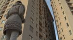 According to the city development urbanistic plan each residential neighborhood needs to be plan properly according to the certain regulations respecting different restrictions in the scale of the city and in the scale of smaller residential neighborhood. In this example of Tibra Pacific, investor didn't care about any of the regulations and restrictions, instead, the main goal was to build as much buildings as possible in order to accommodate more people, without planning school, kindergarten, public spaces and parking places for the residents.
 -
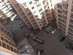 Second issue is that the placement of certain buildings endangered their neighbor buildings, so, some buildings don't get sunlight during the day at all and the view from the most of the apartments is oriented towards other people's balconies and windows on very short distance.
 -
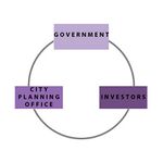 Three major actors of this challenge are Government of Bosnia and Herzegovina, City Planning Administration and Private Investors that equally contribute to it; Government of B&H with clearly not defined regulations that would stop extortion of land primarily intended for residence of people into "commercial" purposes, City Planning Administration of Sarajevo for knowingly approving these inhuman projects and not examining them regarding set regulations and restrictions of construction of these kinds of neighborhoods and finally, Private investors that don't respect basic human needs in respect to living spaces.
 -
 UN's Sustainable Development Goal 11 states that challenges cities face can be overcome in ways that allow them to continue to thrive and grow, while improving resource use and reducing pollution and poverty.
 -
 UN's Sustainable Development Goal 17 is focused on successful sustainable development agenda that requires partnerships between governments, the private sector and civil society built upon principles and values, a shared vision, and shared goals that place people and the planet at the centre.


Your references:
- UN Sustainable Development Goals "https://www.un.org/sustainabledevelopment/"
- Source.ba Online Magazine "http://www.source.ba/clanak/BiH/386226/Sarajevo-postalo-veliko-gradiliste--Nicu-moderne-zgrade-i-naselja-a-koliko-se-postuju-pravila-gradnje"
Landscape Democracy Challenge 3 Abhishek Passan
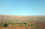
- Lake Pichola: Preserving Character
-
 This is a symbol of historical and cultural relevance so as to preserve its character.
 -
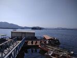 Existing commercial activities hampering the environmental conditions causing water pollution.
 -
 Culture and traditions causing an indirect impact over the environmental condition of the lake.
 -
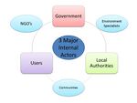 The three main actors are directly or indirectly affected by various external actors.
 -
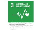 UN's Sustainable Development Goal 3 is strictly violated as the pollution can cause to spread of diseases.
 -
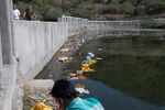
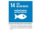 UN's Sustainable Development Goal 14 is also hampered as the waste from the festivals impact on the biologocal conditions of lake disturbing the aquatic life.


Your references:
- UN Sustainable Development Goals "https://www.un.org/sustainabledevelopment/"
- Udaipur Times
Landscape Democracy Challenge 4. Laura Chaverri Flores
- Give a title to your challenge
-
Why Tirrases? The Curridabat county (15.95 km²), where I live, despite having a high degree of economic, educational and urban development; has different neighborhoods marked by important social differences. The district of Tirrases (1.89 km²), is one of the most depressed districts with big social and environmental problems. I believe that this case reflects a Latin American reality where informality causes illegal construction in places of high vulnerability, to the detriment of environmental and landscape quality. I am concerned about the loss of ecological diversity and the issue of social segregation in the area.
-
Social segregation is a very important problem in Latin American cities. The rivers, usually instead of connecting, segregate neighborhoods of wealthy people with the neighborhoods of people with low resources. This generates big problems of disconnection and social division. The wealthy neighborhoods build walls of isolation, which in turn affects the ecological connectivity. In addition, illegal construction in areas of high fragility causes problems of pollution, landslides, climate change, social degradation and loss of biodiversity.
-
The Local Human Development Plan of the Curridabat county indicates that 18% of the inhabitants of Tirrases live in poverty, while 7% live in extreme poverty. The population at social risk has lacked spaces that promote the use of free time for leisure and healthy fun. This has caused problems of delinquency, drugs and lack of environmental education. Urban growth without planning provokes marginalized areas characterized by informal occupation, illegal construction and social exclusion of its inhabitants.
-
The actors are: -Community of Curridabat, especially population of the district of Tirades, The Municipality of Curridabat (local government), Academic sector: including students from the Uladislao Gámez Solano Professional Technical College, La Cometa Educational Project, the Central America School, as well as the University of Costa Rica that can participate in social action and research and NGO organizations
-
caption: UN's Sustainable Development Goal?
-
caption: UN's Sustainable Development Goal?
-
caption: UN's Sustainable Development Goal?
Your references:
- ...
- ...
Landscape Democracy Challenge 5 Salma Malak Bennasser
- Project Taghazout Bay: How about us!
-
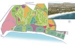 Why Taghazout bay : The project of Taghazout falls within the framework of plan Azur, which is a plan to create 9 resorts in Morocco that respect the principles of sustainable development. The company responsible for the planning of the project claims its support to sustainable development, developing an integrated and sustainable approach to the project by: the integration of the project in its surrounding (Argan forest, hills and sand dunes), preserving the Moroccan culture, values and identity, protecting the environment and promoting tourism as a vector for economic and social development.The project has been certified as being an exemplary project in territorial development promoting a rational model of tourism development.
 -
Sea views and access to the beach: The population of Agadir and of the surrounding villages fear the privatization of the beach or the occupation of the public domain by hotels like what happened to Agadir seaside before 2005 when some parts of the beach were occupied by the hotels affecting the access to the beach. During the summer time The Gadiri people are used to travel to far beaches to enjoy long and large beaches instead of the beach of Agadir which is overcrowded. The beaches are also considered the only attraction in the city and its surroundings. The sea view can also be an element of conflict as the houses of some the villages might lose the sea view they enjoyed before the implementation of the hotels.
-
 Land appropriation: It is an issue that arises whenever there is a big project. The taking of private property for public use or for touristic infrastructure is not without resistance. The lands are sometimes owned by several people or are already the subject of conflict and sometimes people refuse to give up their land.
 -
 Actors: The actors are the commune of Aourir and Taghazout, the two villages that surround the project area..The population of those village and of the city of Agadir and the owners of the hotels.
 -
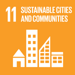 UN's Sustainable Development Goal 11: Make cities inclusive, safe, resilient and sustainable
 -
 UN's Sustainable Development Goal 17: Revitalize the global partnership for sustainable development


Your references:
- http://www.taghazoutbay.ma/index.php/en/
- https://www.un.org/sustainabledevelopment/sustainable-development-goals/
Assignment 5 - Your Democratic Change Process
- You can read more details about this assignment here
- After documenting and reflecting on your challenges you will continue jointly with one of these challenges and design a democratic change process
Your Democratic Change Process
- Add Title
-
caption: ...
-
caption: ...
-
caption: ...
-
caption: ...
Reflection
- ....
- ....
- ....
Conclusion:
- ....
- ....
- ....
Your references
- ...
- ...
- ...