LED Online Seminar 2017 - Working Group 3
--> Back to working group overview
Dear working group members. This is your group page and you will be completing the template gradually as we move through the seminar. Good luck and enjoy your collaboration!
Assignment 1 - Reading and Synthesizing Core Terminology
- You can read more details about this assignment here
- Readings are accessible via the resources page
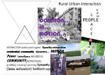
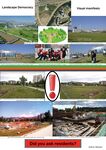
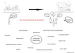
Step 1: Your Landscape Democracy Manifestoes
Step 2: Define your readings
- Please add your readings selection for the terminology exercise before April 12:
A: Landscape and Democracy - Mapping the Terrain
- Mira Hennerkes
- European Charter on Participatory Democracy
Landscape Concepts:
- Sobhan Saadat
- Lynch, Kevin. (1960): The Image of the City
B: Concepts of Participation
- Edvin Memić
- Day, Christopher (2002): Consensus Design, Architectural Press
C: Community and Identity
- Melanie Schnürer
- Welk Von Mossner, Alexa (2014): Cinematic Landscapes
D: Designing
- Mira Hennerkes
- Hester, Randolph (1995) Life, Liberty and the Pursuit of Sustainable Happiness
E: Communicating a Vision
- Melanie Schnürer
- Storytelling example from the Scottish Islands
Steps 3 and 4: Concepts Selection and definition
- Each group member selects three relevant concepts derived from his/her readings and synthesize them/publish them on the wiki by April 30, 2017
- Group members reflect within their groups and define their chosen concepts into a shared definition to be posted on the wiki by May 10, 2017.
- Other group members will be able to comment on the definitions until May 20, 2017
Concepts and definitions
Author 1:
- Concept 1
- add you definition here with 2-3 concise sentences. Do not copy paste text from others, use your own words. Make reference to resources used.
- Concept 2
- .....
- Concept 3
- ....
Author 2: Edvin Memić
- Concept 1
- If several people have different opinions about something, does that mean that they need to seek a compromise, although the compromis is kind of giving up from own opinions. But if it will lead to a better situation in general, this is not a bad solution. (Day, Christopher (2002): Consensus Design, Architectural Press)
- Concept 2
- Voting is not good because of the fact that majority opinion is used, while minority opinion is rejected, although sometimes it may be better. (Day, Christopher (2002): Consensus Design, Architectural Press)
- Concept 3
- Consensus is best for making decisions. When a consensus is reached, the decision is made step by step, the opinion of individuals is reconsidered, and the best solution for the group is accepted. Although it takes more time. (Day, Christopher (2002): Consensus Design, Architectural Press)
Author 3: Mira Hennerkes
- Concept 1
- Concept 2
- Concept 3
- Concept 4
Author 4: Melanie Schnürer
- Essential features (Welk Von Mossner, Alexa (2014): Cinematic Landscapes, In: Topos, No. 88, 2014.)
- Essential features of a narrative film are, besides the natural and built environment, also the authenticity of the landscape, which plays an active role in a fiction film. "Beasts of the Southern Wild" (a film by Benh Zeitlin) is a good example for such a cinematic narrative.
- The space (Welk Von Mossner, Alexa (2014): Cinematic Landscapes, In: Topos, No. 88, 2014.)
- The space, which represents the cinematic environment, is the space in which the action takes place; in the film language this is called "setting". This room has to be carefully constructed, and for the cinematic environment all kinds of tricks are used.
- Realization of a visually spectacular backdrop (Welk Von Mossner, Alexa (2014): Cinematic Landscapes, In: Topos, No. 88, 2014.)
- In the past, a landscape was created on a soundstage of a film studio for the realization of a visually spectacular backdrop for a narrative; today such scenes are replaced by computer animations. The actors shoot in front of a green screen.
- City and urban design framework (Storytelling example from the Scottish Islands)
- For cities, it is important to gain an overview by creating an urban design framework that can be used to coordinate the existing projects and then use this as the basis for future development documents and master plans for the individual sites.
- Working with other studies and initiatives (Storytelling example from the Scottish Islands)
- WMUDs, which had created the urban design framework, worked in parallel with other studies and initiatives (e.g. Townscape Heritage Initiative (THI), Pierhead Project) to submit a proposal to the city on how to improve the contrasts between the individual elements.
- Future of the city (Storytelling example from the Scottish Islands)
- In order to obtain a good result, for the future of the city, one must think about various questions, e.g. How does the city look like in a few years?; How can other districts be integrated? ... Such questions are answered either positively or negatively. Sometimes a compromise must be sought for some questions.
Step 5: Reflection
- Please write, as a group, a 250 words reflection on your discourse and document it here
Step 6: Revised manifestoes
- please look again at your initial manifestoes and update them with any new aspects/prespectives you have taken up during this seminar
- Updatedmanifesto1.jpg
xy's updated manifesto
- Updatedmanifesto2.jpg
xy's updated manifesto
- Updatedmanifesto3.jpg
xy's updated manifesto
- Updatedmanifesto4.jpg
xy's updated manifesto
- Updatedmanifesto5.jpg
xy's updated manifesto
Assignment 2 - Your Landscape Symbols
- You can read more details about this assignment here
Landscape Symbols Sobhan Saadat
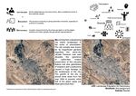
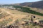
The topography of the zone is very especial, where both lower level of stream and high level of the mountains run alongside eachother. The mountain provides an urban opportunity of hiking for the citizens. However, it is noteworthy that the city in general is a large plain between some of the lower chain of well-known Zagros mauntain stretching from north-west of country to the south-west, 29°39'22.6"N 52°29'53.3"E.
Chamran linear park is one of the most important spots in the city Shiraz and in my opinion is the most noticeable landscape symbol in the city. Not only in terms of size but also in terms of variety of nature and non-natural elements it encompasses. A very unique combination of stream with gardens and trees on one side and the mountain and buildings along the linear park on the other side, 29°37'59.6"N 52°29'29.5"E.
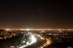
It makes the place one of the zones to breathe fresh air and picnic at the weekends. Also provides many activates within its range that hardly ever dim around the clock, especially when the weather is warm. In addition, the road with the same name carries good number of vehicles from the city center to the northern part of the city which has become growingly more popular to inhabit. Although the last trait might be considered as a disadvantage, it is inevitable that is a factor in the dynamic quality of the zone, 29°39'46.9"N 52°29'16.4"E.
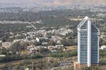
However, recently due to the new phase of constructions and also little amount of precipitations quality of this valuable urban area has diminished. There are many zones in Shiraz that are disadvantaged from the same trend and unfortunately the authorities are doing the least to encounter the damages to the landscape of the city which ironically is very fragile and vulnerable, 29°39'10.5"N 52°30'03.5"E.
Landscape Symbols Edvin Memić
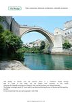
Old Bridge in Mostar over the Neretva River is a UNESCO World hertage and when is built, it was the largest arch structure in the world. Sulejman the Magnificent ordered to build in 1566, and the architect was Mimar Hajrudin. Connects two parts of the city, and symbolizes connection, historical, architecture, culturally. Geo-location: 43° 20′ 13.57″ N, 17° 48′ 53.39″ E
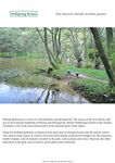
Wellspring Bosnia is a source in central Bosnia and Herzegovina. The source of the river Bosna, and one of most famous landmarks of Bosnia and Herzegovina. Bosnia Wellspring located on the ouskirts of Sarajevo. One of the most famous parts of the natural beauty of the region. It is famous tourist attraction and it’s a symbol historical, culturally, recreation, greenery. Geo-location: 43°49'10"N 18°16'10"E
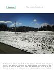
Bijambare are law protected area by the Sarajevo Canton. It is located on the main road Sarajevo - Tuzla. Spreads on 370 hectares and includes coniferous forests, pastures, two small rivers, and six caves. The largest cave is called Main Bijambare Cave. In one of the caves discovered the remains of the cave man, a tool a stone processing, and remnants of animals. Symbol is recreation, history, clean air. Geo-location: 44° 4′ 48.17″ N, 18° 30′ 55.1″ E
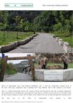
Place name: Alley of ambassadors in Sarajevo. The trees are planted on both sides of the street, the street is used exclusively as a pedestrian zone. This is a friendly relationship between the countries, Bosnia and Herzegovina and state accredited ambassador. Wood represents life, something that is growing. It is a symbol connecting, walking, memories. Geo-location: 43°51'29.1"N 18°26'37.1"E
Landscape Symbols Mira Hennerkes
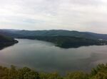
The picture shows the Edersee, one of the largest water reservoirs in Germany. The reservoir is located in the state of Hessen, about one hour from Kassel. The construction of the Edersee Dam took place around 1910. Three villages in the former valley vansihed under the water surface and about 900 people has been relocated for the project (51 11 15N 9 3 29E).
Landscape Symbols Melanie Schnürer
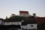
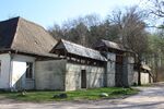
Castle Altenberg was mentioned for the first time more than 600 years ago. It was destroyed and rebuilt several times. Under the rule of Franz Ferdinand von Syrgenstein, the present castle was built in 1693. In 1986, Princess Clothilde of Liechtenstein acquired Schloss Altenberg (Geo location: 48°39'29"N; 10°18'11"E)
Landscape Symbols Author 5
The city of Palmas is the last planned capital in the XX century and was designed to be the capital of Tocantins, the newest state of Brazil. Palmas was designed between two landmarks, one natural (Carmo's Sierra) and the other artificial (Lajeado's Lake). The city has lots of other landmarks, such as the Girassol's Square (2nd biggest square in the world) and the Aragauia Palace. The square is located in the meeting point of the two main axial avenues of Palmas.
- Symbol yourname photovoice2
add a caption (one paragraph max) description of the symbolism, interpretation, as well as geo-location
- Symbol yourname photovoice3
add a caption (one paragraph max) description of the symbolism, interpretation, as well as geo-location
- Symbol yourname photovoice4
add a caption (one paragraph max) description of the symbolism, interpretation, as well as geo-location
- Symbol yourname photovoice5
add a caption (one paragraph max) description of the symbolism, interpretation, as well as geo-location
Assignment 3 - Role Play on Landscape Democracy "movers and shakers"
- You can read more details about this assignment here
Assignment 4 - Your Landscape Democracy Challenge
- You can read more details about this assignment here
- Each group member will specify a landscape democracy challenge in his/her environment
Landscape Democracy Challenge 1
- Give a title to your challenge
- Yourname challenge 1.jpg
caption: why did you select this case?
- Yourname challenge 2.jpg
caption: what is the issue/conflict (1)
- Yourname challenge 3.jpg
caption: what is the issue/conflict (2)
- Yourname challenge 4.jpg
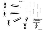
caption: who are the actors?
Your references:
- ...
- ...
Landscape Democracy Challenge 2
- Bicycle path
Your references:
- http://girodisarajevo.ba/2015/04/osvrt-na-izgradnju-biciklisticke-staze-u-sarajevu/
- https://www.klix.ba/vijesti/bih/grad-sarajevo-biciklisticka-staza-ce-biti-po-evropskim-standardima/141028083
Landscape Democracy Challenge 3
- Give a title to your challenge
- Yourname challenge 1.jpg
caption: why did you select this case?
- Yourname challenge 2.jpg
caption: what is the issue/conflict (1)
- Yourname challenge 3.jpg
caption: what is the issue/conflict (2)
- Yourname challenge 4.jpg
caption: who are the actors?
Your references:
- ...
- ...
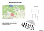
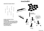
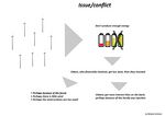
Landscape Democracy Challenge Melanie Schnürer
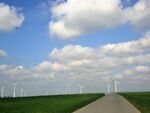
- Wind turbines don't produce enough energy
Your references:
- http://gegenwind-starnberg.de/tag/zoeschingen/
- http://www.br.de/nachrichten/schwaben/inhalt/windraeder-zoeschingen-108.html
Landscape Democracy Challenge 5
- Give a title to your challenge
- Yourname challenge 1.jpg
caption: why did you select this case?
- Yourname challenge 2.jpg
caption: what is the issue/conflict (1)
- Yourname challenge 3.jpg
caption: what is the issue/conflict (2)
- Yourname challenge 4.jpg
caption: who are the actors?
Your references:
- ...
- ...
Assignment 5 - Your Democratic Change Process
- You can read more details about this assignment here
- After documenting and reflecting on your challenges you will continue jointly with one of these challenges and design a democratic change process
Your Democratic Change Process
- Add the title of your project
- Yourgroupname 2017 powermap.jpg
a power map identifying who is affected by the challenge and who is influencing it
- Yourgroupname 2017 change process (1).jpg
Look at the various methods and tools available and think how they can be applied creatively. Think about the needs of different stakeholder groups - you may need a methodical mix to address them all. Illustrate graphically how these methods/tools might be applied in a short, medium and long-term perspective.
- Yourgroupname 2017 scenario.jpg
a scenario illustrating how these tools can be applied within a short, medium and long term perspective involving the groups you want to address, this should include a process timeline
Reflection
- Evaluate in the group how far your ideas either built on the theoretical frame that has been introduced to you during this seminar or react to this by filling a potential gap (approx 150 words)
Your references
- ....
- ....
- ....
- ....
