LED Online Seminar 2017 - Working Group 1
--> Back to working group overview
Dear working group members. This is your group page and you will be completing the template gradually as we move through the seminar. Good luck and enjoy your collaboration!
Assignment 1 - Reading and Synthesizing Core Terminology
- You can read more details about this assignment here
- Readings are accessible via the resources page
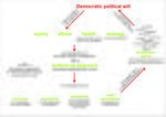
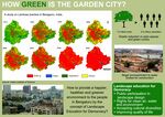
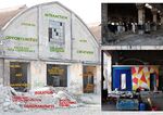
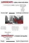
Step 1: Your Landscape Democracy Manifestoes
Step 2: Define your readings
- Please add your readings selection for the terminology exercise before April 12:
A: Landscape and Democracy - Mapping the Terrain
- The European Landscape Convention (Giya Elizabeth George)
Landscape Concepts:
- Lynch, Kevin. (1960): The Image of the City, Cambridge, Mass.: MIT Press (Giulia Chiussi)
B: Concepts of Participation
- Hester, Randolph (2006): Design for Ecological Democracy - Fairness
- David, Harvey (2003): The Right to the City, International Journal of Urban and Regional Research, Volume 27, Issue 4, pages 939–941 (Giulia Chiussi)
C: Community and Identity
- Hester, Randolph (2006): Design for Ecological Democracy (Mansura Perveen)
- Welk Von Mossner, Alexa (2014): Cinematic Landscapes (Mansura Perveen)
- Nassauer, Joan Iverson (1995): Culture and Changing Landscape Structure, Landscape Ecology, vol. 10 no. 4. (Giulia Chiussi)
D: Designing
- Reading selected: Hester, Randolph: Life, Liberty and pursuit of Sustainable Happiness (Giya Elizabeth George)
- Vall, N. (2013): Social engineering and participation in Anglo-Swedish housing 1945–1976: Ralph Erskine's vernacular plan, Planning Perspectives, 28(2), 223-245 (Giulia Chiussi)
- Pritzker Prize winning architect Alejandro Aravena on sustainable design and community involvement in Chile (Mansura Perveen)
E: Communicating a Vision
- Participant: Haniyeh Golzardi
- Reading selected: Storytelling example from the Scottish Islands
- Online decision making with loomio
- Reading the Landscape' by Simon Bell, EMU Tartu
Steps 3 and 4: Concepts Selection and definition
- Each group member selects three relevant concepts derived from his/her readings and synthesize them/publish them on the wiki by April 30, 2017
- Group members reflect within their groups and define their chosen concepts into a shared definition to be posted on the wiki by May 10, 2017.
- Other group members will be able to comment on the definitions until May 20, 2017
Concepts and definitions
Giulia Chiussi:
- IMAGEABILITY (p.9 The image of the city (A), Kevin Lynch)
The property of an object to strike a chord of the observer.
It can be given by the physical image but it also can be a feeling perceived through all the senses.
- AFFORDANCE (P.232 Culture and changing landscape structures (C), Joan Iverson Nassauer)
The emotional involvement between an object and his user: the shape of the object suggests the way to approach with. It's a potential property of a meeting.
- Giya Elizabeth George
- ....
Haniyeh Golzardi:
- Concept 1
- Urban design framework provide a strategic overview that coordinate existing projects and act for future development masterplans.
- The most important step before landscape planning is to understand the process that formed the landscape and the pressure for changes on that.
- Reading the landscape is not about the valuing it but it's about describing or characterising it and give the landscape a name.
Author 3:
- ......
- .......
- .......
Author 4:
- ......
- .......
- .......
Author 5:
- ......
- .......
- .......
Step 5: Reflection
- Please write, as a group, a 250 words reflection on your discourse and document it here
Step 6: Revised manifestoes
- please look again at your initial manifestoes and update them with any new aspects/prespectives you have taken up during this seminar
- Updatedmanifesto1.jpg
xy's updated manifesto
- Updatedmanifesto2.jpg
xy's updated manifesto
- Updatedmanifesto3.jpg
xy's updated manifesto
- Updatedmanifesto4.jpg
xy's updated manifesto
- Updatedmanifesto5.jpg
xy's updated manifesto
Assignment 2 - Your Landscape Symbols
- You can read more details about this assignment here
Giulia Chiussi
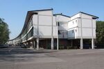
THE TRAIN this is a Giuseppe Vaccaro project. Vaccaro is the architect who built our Enineering and Architecture School Location and he conceived also this Democratic Space working with his team and people. Now it's still a place where people meet to take care of Everybody's Green. The Train is the name that people gave to this 'spine' Complex situated in the Barca District in Bologna. Via della Barca, Bologna. GEOlocation:44°29'42.9"N 11°17'06.0"E
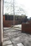
SPIRAL SQUARE this is a little square that is behind the San Domenico Basilica. Many of italian's squares are in front of churches, the symbol of the Christian Power, this is behind. It's intimate and gives you a plaesant close feeling with other people: the Big Tree in the eye connects all. The spiral ivites you to think: it gives you the possibility to perceive this sense of peace by giving your space. Vicolo dell'Orto, Bologna. GEOlocation:44°29'22.7"N 11°20'40.7"E
- Symbol yourname photovoice4
add a caption (one paragraphNich
- Symbol yourname photovoice5
add a caption (one paragraph moas
Haniyeh Golzardi
- Symbol yourname photovoice4
add a caption (one paragraph max) description of the symbolism, interpretation, as well as geo-location
- Symbol yourname photovoice5
add a caption (one paragraph max) description of the symbolism, interpretation, as well as geo-location
Giya Elizabeth George
Madras War Cemetery is a World War memorial cemetery in Chennai (Madras), Tamil Nadu, India, established in 1952 by the Imperial War Graves Commission, to pay tribute to the men and women who sacrificed their lives in World War II. The memorial does not contain any buried dead-bodies, but has plaques with the names of many British soldiers who died in both the World Wars, with the inscription ‘Their name liveth for evermore’. It symbolizes the sacrifice and noblest deeds of the soldiers along with the historical evidences of British rule in India. It is stylized as a lawn cemetery and is currently maintained by the Commonwealth War Graves Commission and Government of India. Geo location: 13° 0′ 51.48″ N, 80° 11′ 39.84″ E.
Shisha Gumbad (literal English translation: glass dome) is a tomb of the Lodhi Dynasty and is believed to have possibly been constructed in the late 15th century. There are four tombs in the Lodhi Gardens including the Shisha Gumbad. Initially, all the tombs were built independently and were not connected. In early 20th century, a park was developed which was inaugurated by Lady Willingdon bringing the four monuments into one garden. The garden is an important part of Indian history and is open for public access. Geo location: 28°35′37.3884″N 77°13′12.6192″E.
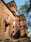
The Basilica of Bom Jesus (Portuguese: Basílica do Bom Jesus) is located in Goa, India. The basilica holds the mortal remains of St. Francis Xavier. The church is located in Old Goa, which was the capital of Goa in the early days of Portuguese rules. It is considered to be one of the best examples of baroque architecture in India and is a landmark in the history of Christianity. The Basilica of Bom Jesus is almost 412 years old and is open to the public every day. Geo location: 15°30′3.14″N 73°54′41.44″E.
- Symbol yourname photovoice4
add a caption (one paragraph max) description of the symbolism, interpretation, as well as geo-location
- Symbol yourname photovoice5
add a caption (one paragraph max) description of the symbolism, interpretation, as well as geo-location
Saeid Saadat
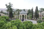
Hafezie Garden; is one of the outstanding gardens of Shiraz. In my eyes, this garden is sending considerable messages, which are note worthy. This place is holding different aspects of Iranian dignity;such as historical,political,traditional and cultural aspects. First of all, this garden was promoted during the Pahlavi dynasty and the amazing monument was constructed in that era as well. Secondly, the memorial structure is symbol of Hafez and his manner of living, which was designed by French Architect André Godard. Moreover, the Garden also is following the discipline of Persian Gardens,which dating back to more than 2500 years ago, with its logical axis and mathematical distribution of elements on context. Apart from all of these factor I should bring up these days condition of the place, this interesting place with its pavilion and open corridor is one of the rarest places in Shiraz which calls people, from every level of society without considering the gender, position or age to come and chill in great atmosphere. The Garden and the Tomb is welcoming people for reading Hafez poetry, singing different poems of different poets, celebrating new year or celebrating the religious events. So, liberality and democratic condition of this garden in this small scale can be felt if you have experienced life condition of non-democratic society like Iran.
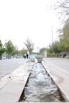
Chamran linear park, a place where people are spending time to have fun. This place was constructed along side a main boulevard(with same name). In this place different elements can be found which are representing combination of modern and classic arts. one of them is illustrated in this pic. A small stream which crossed a bowl and break it. the axis and the way of presenting are interesting
- Symbol yourname photovoice4
add a caption (one paragraph max) description of the symbolism, interpretation, as well as geo-location
- Symbol yourname photovoice5
add a caption (one paragraph max) description of the symbolism, interpretation, as well as geo-location
Mansura Perveen
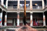
Ruplal House,a 19th century palace of great heritage value, decaying in negligence. Ruplal House,a 19th century palace of great heritage value in old Dhaka Bangladesh.This Neo classical architecture has been take possession by local settler. Ripped of the signs of its past grace and grandeur. This building should have been preserved heritage of old architecture in old city as manifest of its flourish history.This picture is taken in the “ Dhaka art summit” festival.Geo location 23° 42′ 13.1″ N, 90° 24′ 49.1″ E
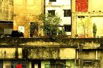
Dhaka is the densely populated city where density is 45,000 people per square kilometers. Closely knit, shabby looking low rise structures forming such unruly roof-scapes-a very common picture in Dhaka. The cow on the roof bears evidence of acute shortage of land in the densely populated city. This picture is taken before the 2nd largest religious festival. Geo location 23°47'07.0"N 90°25'06.2"E
This photo is taken on the way of my village home :Modhukhali, Dhaka,Bnagladesh. Rich green paddy fields, spread across the horizon, is perhaps the most familiar picture of rural Bangladesh. And it is indeed remarkable how the limited arable lands of the country managed till now to supply such a large population with food. However, the greed of the real-estate developers, coupled with poor governance, is making it extremely difficult to save the agricultural lands from the grasp of the businessmen. Geo location 23°50'04.2"N 90°33'38.3"E
Assignment 3 - Role Play on Landscape Democracy "movers and shakers"
- You can read more details about this assignment here
Assignment 4 - Your Landscape Democracy Challenge
- You can read more details about this assignment here
- Each group member will specify a landscape democracy challenge in his/her environment
Landscape Democracy Challenge 1
- Give a title to your challenge
- Yourname challenge 1.jpg
caption: why did you select this case?
- Yourname challenge 2.jpg
caption: what is the issue/conflict (1)
- Yourname challenge 3.jpg
caption: what is the issue/conflict (2)
- Yourname challenge 4.jpg
caption: who are the actors?
Your references:
- ...
- ...
Landscape Democracy Challenge 2
- Give a title to your challenge
- Yourname challenge 1.jpg
caption: why did you select this case?
- Yourname challenge 2.jpg
caption: what is the issue/conflict (1)
- Yourname challenge 3.jpg
caption: what is the issue/conflict (2)
- Yourname challenge 4.jpg
caption: who are the actors?
Your references:
- ...
- ...
Landscape Democracy Challenge 3
- Give a title to your challenge
- Yourname challenge 1.jpg
caption: why did you select this case?
- Yourname challenge 2.jpg
caption: what is the issue/conflict (1)
- Yourname challenge 3.jpg
caption: what is the issue/conflict (2)
- Yourname challenge 4.jpg
caption: who are the actors?
Your references:
- ...
- ...
Landscape Democracy Challenge 4
- Give a title to your challenge
- Yourname challenge 1.jpg
caption: why did you select this case?
- Yourname challenge 2.jpg
caption: what is the issue/conflict (1)
- Yourname challenge 3.jpg
caption: what is the issue/conflict (2)
- Yourname challenge 4.jpg
caption: who are the actors?
Your references:
- ...
- ...
Landscape Democracy Challenge 5
- Give a title to your challenge
- Yourname challenge 1.jpg
caption: why did you select this case?
- Yourname challenge 2.jpg
caption: what is the issue/conflict (1)
- Yourname challenge 3.jpg
caption: what is the issue/conflict (2)
- Yourname challenge 4.jpg
caption: who are the actors?
Your references:
- ...
- ...
Assignment 5 - Your Democratic Change Process
- You can read more details about this assignment here
- After documenting and reflecting on your challenges you will continue jointly with one of these challenges and design a democratic change process
Your Democratic Change Process
- Add the title of your project
- Yourgroupname 2017 powermap.jpg
a power map identifying who is affected by the challenge and who is influencing it
- Yourgroupname 2017 change process (1).jpg
Look at the various methods and tools available and think how they can be applied creatively. Think about the needs of different stakeholder groups - you may need a methodical mix to address them all. Illustrate graphically how these methods/tools might be applied in a short, medium and long-term perspective.
- Yourgroupname 2017 scenario.jpg
a scenario illustrating how these tools can be applied within a short, medium and long term perspective involving the groups you want to address, this should include a process timeline
Reflection
- Evaluate in the group how far your ideas either built on the theoretical frame that has been introduced to you during this seminar or react to this by filling a potential gap (approx 150 words)
Your references
- ....
- ....
- ....
- ....
