LED2LEAP 2020 - Freising Team 8: Difference between revisions
| Line 77: | Line 77: | ||
[[File:Community relation.JPG]] | [[File:Community relation.JPG]] | ||
[[File:Cause effect relation. | [[File:Cause effect relation.JPG]] | ||
== Summary of your learnings from the transnational discussion panel on April 22 == | == Summary of your learnings from the transnational discussion panel on April 22 == | ||
Revision as of 22:28, 5 May 2020
>>>back to working groups overview
| Area | Bani Knanah County | |
| Place | Irbid City | |
| Country | Jordan | |
| Topics | Agriculture / Rural development | |
| Author(s) | Amal-Kanimozhi-Kamolshanok-Doraed | |

| ||
Landscape Democracy Rationale
- Why do you think this community context is relevant from a landscape democracy perspective? What is your hypothesis considering the landscape democracy challenges?
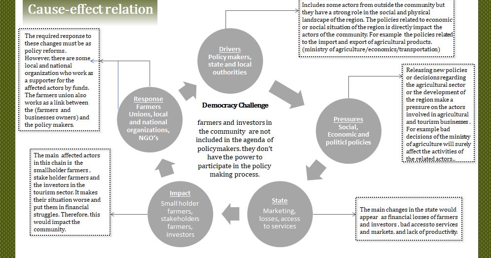
- It is a rural region with good agricultural land and natural resources. meanwhile, farmers in this community are facing some issues regarding their activities which make it less profitable and force them to live in bad economic situation. these farmers are not involved on the policy making process. which make the national or state policies to play a negative role in their community
Location and scope
- You can edit this map with the map editor
- Next to showing us where you are, you may also use this map to localise different focus themes of your community
6120593479735:32.74483592201403,35.80024046652661~study area ~Bani Knanah county
Phase A: Mapping your Community
Welcome to your community and its landscape
Bani Kinanah County is one of nine counties in Irbid. It represents an important center for agriculture because of the breadth of its fertile land, its rich red soil and its moderate climate. It is one of the largest counties in Irbid governorate in terms of population, the majority of its residents work in the public sector, trade and agriculture. The county includes 27 towns with population ranging between 165 and 11706 inhabitants The county is an extension of three types of terrains; plain, mountain and valley. Its land is considered as one of the richest agricultural lands in the country where it produces about 11% of total olives productions in Jordan.
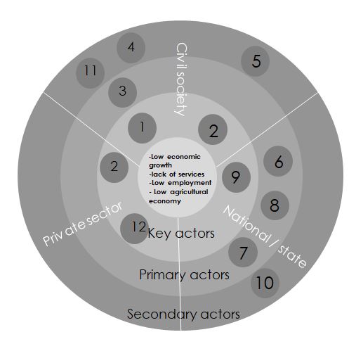
Groups of actors and stakeholders in our community
1- smallholder farmers
2- stakeholder farmers
3- Jordanian Farmers union
4- commuters Rural-Urban job commuters
5- local workers :.
6- King Abdullah fund for development:
7- Woman microfinance fund association
8- International NGO’s
9- policy makers
10- Local authorities / municipalities
11- Refugees
12- investors in tourism sector
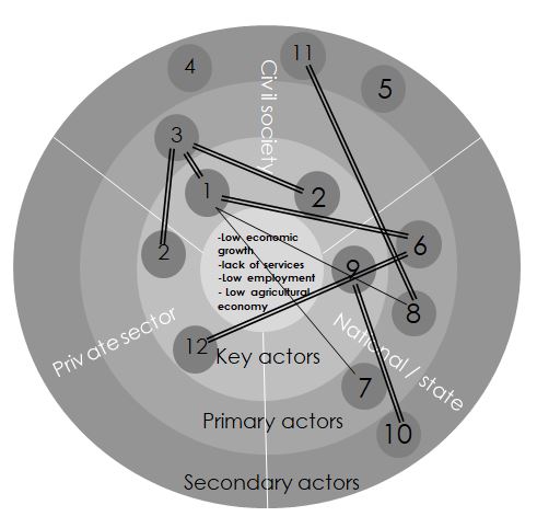
Relationships between your actors and groups
Summary of your learnings from the transnational discussion panel on April 22
On April 22 you will present the PPT version of this first assignment to other seminar groups working in other geographical community contexts. Please give here a short summary of your learnings during this presentation, for example:
- Other analytical approaches
- Other representation styles
- Other value schemes: any surprises?
- Constructive comments we received on our presentation
Theory reflection
Focusing on the topics about poverty and economical developments, how to improve and integrated idea as proposal to the community.
Evolving liabilities of income by promoting agricultural and attraction sectors.
Indicated our main group of users as first priorities which are mainly farmers, local worker.
Difficulties:
Unable to access the community by ourselves, we worked based on collected information and assumption of how it will affect. In the region, almost all communities have the same evaluation and value with small differences. Have to assuming and eliminating some minor issues.
Reading / Theories relations:
Landscape based on economy : agricultural economy – farmers, workers. All interrelated to private and public sectors Stories behind cultural and historical Landscape. Change of Time related to quality of living. Feedback loop for planning, observing , monitoring action and reflection.
[[File: Reflection-1.JPG]] [[File: Reflection-2.JPG]]
References
- give a full list of the references you have used for this section
Phase B: Democratic Landscape Analysis and Assessment
The Scene in your Story of Analysis
- Describe your landscape democracy challenge. What is the physical scene, specific description of the landscape? What are the socio-economic and political characteristics of place? Are there any important contextual elements?
- add the corresponding visual from your presentation to the image gallery below
- Yourcase scene1.jpg
add a caption
The Actors in your Story of Analysis
- Describe the characters and their role in the story. Are they major or minor characters? Are there any key relationships that need to be defined?
- add the corresponding visual from your presentation to the image gallery below
The Story of Analysis
- Describe the plot of the story and how it plays out.
- add the corresponding visual from your presentation to the image gallery below
- add as many additional images as you like
- Yourcase story2.jpg
add a caption
Reflect on your Story of Analysis
- How did the tools you chose for landscape analysis fit your community? Reflect on the questions: What did you carry? Why did you carry? How did you carry? What remains after you've left? (150 words)
- add the corresponding visual from your presentation to the image gallery below
- Yourcase refelction1.jpg
add a caption
Phase C: Collaborative Visioning and Goal Setting
* template coming
Phase D: Collaborative Design, Transformation and Planning
* template coming
Phase E: Collaborative Design, Transformation and Planning
* template coming
= Phase E: Collaborative Evaluation and Future Agendas * template coming
Process Reflection
- Reflect in your intercultural and interdisciplinary team on the outcomes of your study
- Which limitations were you facing?
- What have you learnt from each other?
- What would you do differently next time?
- You can also use diagrams/visuals
- 250 words text


