LED Online Seminar 2019 - Working Group 7
--> Back to working group overview
Dear working group members. This is your group page and you will be completing the template gradually as we move through the seminar. Good luck and enjoy your collaboration!
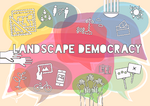
Assignment 1 - Reading and Synthesizing Core Terminology
- You can read more details about this assignment here
- Readings are accessible via the resources page
Step 1: Your Landscape Democracy Manifestoes
-
 Amir's manifesto
 -
 Nahian's manifesto
 -
 Gaia's manifesto
 -
 Júlia's manifesto


Step 2: Define your readings
- Please add your readings selection for the terminology exercise before April 24:
A: Landscape and Democracy
1. Amir - Why is landscape beautiful? - Burckhardt, Lucius (1979)
2. Júlia - Urban Planning and Democracy - Júlia (1957)
3. Gaia - Meinig, D. W. (1979): "The Beholding Eye: Ten Versions of the Same Scene."
B: Concepts of Participation
1. Amir - Consensus Design - Day, Christopher (2002)
2. Gaia - Gaventa, John: The Powerful, the Powerless, and the Experts
3. Nahian - Hester, Randolph (2005): Whose Politics, Landscape Architecture
C: Community and Identity
1. Amir - Cinematic Landscapes - Welk Von Mossner, Alexa (2014)
2. Nahian - Nassauer, Joan Iverson (1995): Culture and Changing Landscape Structure, Landscape Ecology, vol. 10 no. 4.
D: Designing
1. Júlia - Design for Ecological Democracy - Randolph T. Hester (2006)
2. Gaia - Hester, Randolph: Life, Liberty and the Pursuit of Sustainable Happiness
3. Nahian - Pritzker Prize winning architect Alejandro Aravena on sustainable design and community involvement in Chile
E: Communicating a Vision 1. Júlia - - (0)
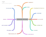
Steps 3 and 4: Concepts Selection and definition
- Each group member selects three relevant concepts derived from his/her readings and synthesize them/publish them on the wiki by May 15, 2019
- Group members reflect within their groups and define their chosen concepts into a shared definition to be posted on the wiki by June 12, 2019.
- Other group members will be able to comment on the definitions until June 30, 2019
- Each group will also report on their process to come to a set of shared definitions of key landscape democracy concepts on the wiki documentation until July 12, 2019
Concepts and definitions
Author 1: S.Amir H.Shahrestani
- Landscape and Democracy - Why is landscape beautiful? - Burckhardt, Lucius (1979)
The outcome of the people view of the same landscape is doubtless highly individual and every person has different aspect and criteria of it. The opinion of beautiful or ugly landscape comes from the people previous idea (childhood stories), therefore the people have different judgments.
- Concepts of Participation - Consensus Design - Day, Christopher (2002)
Better way to make ethical decisions is defined as a democratic way and consensual approach. In the democracy the majority's demands are influential and the minority’s requests are disregarded. Getting a more comprehensive solution (equitable, productive, conscious, participator) compromising is defined as a step to reach collective decisions and consensus.
- Community and Identity - Cinematic Landscapes - Welk Von Mossner, Alexa (2014)
Image of the landscape allows us to establish a relationship with the place through the sense of belonging. It performs an effective role in the transmission of the story by reflecting the identity of the space.
Author 2: Ildikó Júlia Kozma
- Landscape and Democracy
The role of the public in urbanism should be stronger. If we want more democratic cities, city dwellers must have more knowledge about the built environment which surround them. Without that they can’t live with their democratic rights.
- Designing
Ecology and democracy is to separate thing, but together they can give a better solution to many problems of urbanism. With well defined principles we can use ecological methods during designing.
- Communicating a Vision
In participatory design communicating your vision is a key element. Presentations hold by professionals, coauthoring design and all different kind of verbal and nonverbal communication method are needed to understand each other.
Author 3: Gaia Uguccioni
- Landscape and Democracy
Every landscape hides a meaning that is not explicit in the ordinary forms. Is a concept that lies utterly beyond science, that holds ideas, impressions and ineffable complexities that depends on how we are affected by it and from the values we associate to it.
- Concepts of Participation
Partecipatory processes are a form of access to a paradigm which the people had a little part in creating. Starts with the reappropriation of knowledge by those who are affected by it and evolves as a strategy in which the powerless develop, create, gain control and systematize their own science.
- Designing
In the modern broad cities is evident the disassociation from community and environment and the human behavior appear antagonistic to sustainability. Holistic insight should be pursuit to guide the design of urban forms and to find new directions for a reformulation of intents and ideals of fulfillment.
Author 4: Nahian Zobaid
- Concepts of Participation
A participatory approach in any development involves the community in Design process and give them the right to express their thought, vision and need. This concept can empower the unprivileged group of society if sensibly chosen in the design process.
- Community and Identity
Community identity is shaped by the custom, social and geographical environment of a particular place. Vernacular landscape are good example of community identity, as it represents the adaptation and thought process of local farm workers, land developers, home owners and other local professionals.
- Designing
Designing is the combination of multiple problems that leads to a simple yet innovative solution. The Designer needs to translate the force of people, common sense and nature into form to built a socially and climatically responsive design.
Step 5: Reflection
Step 6: Revised manifestoes
- please look again at your initial manifestoes and update them with any new aspects/prespectives you have taken up during this seminar
-
 Author's updated manifesto
 -
Author's updated manifesto
-
Author's updated manifesto
-
Author's updated manifesto

Assignment 2 - Your Landscape Symbols
- You can read more details about this assignment here
Landscape Symbols Author 1: Júlia Ildikó Kozma
-
 “Szabihíd” project, Liberty Bridge urban picnic “Szabihíd” project started in 2017 when the Libert Bridge was closed due to constartion work. City dwellers and turist went there to enjoy the unique opportunity. At the beggining the city administration couldn’t handel the situation so they forbide to go there, but after a local orgaziation embraced this need and convienced the municipality to make a legal from. Since then the birdge is free from cars during the summer weekends and there are all different kind of activites makes this project more and more popular. 47.485755, 19.054959
 -
 Buda Castle, Hungarian National Gallery, Széchenyi National Library During the historical times the castle was the place for the king, but these days it is open for the public. People not only can see the castle but the Hungarian National Gallery and also a Széchenyi National Library take place there. It symbolize a democratyc change which maybe not obvios if you doesn’t have some knowledge about the place. 47.502262, 19.032800
 -
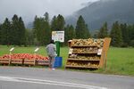 Vegetable stands In the countryside small vegetable stands offer opportunity to buy fresh crop right form the a infield. Sometimes the owner is selling to you, sometimes only a box is there to collect the cost. I think it is also a symbol of trust and trust is something essentail for democracy. This system would not work without respect and understantment of the value of work. 47.557538, 10.749554


Landscape Symbols Author 2: Gaia Uguccioni
-
![Bologna città [W]etropolitana_Not a subway access, but a sign of artistic performances that took place in those spaces and that has become part of a stratified landscape. A modern monument that represents the aesthetics of the provisional, infiltrates our landscape in a work of continuous adaptation, with a tangible subliminal act plausible enough to become familiar and mimically incorporated.](/images/thumb/1/1b/1_Wetropolitana.jpg/112px-1_Wetropolitana.jpg) Bologna città [W]etropolitana_Not a subway access, but a sign of artistic performances that took place in those spaces and that has become part of a stratified landscape. A modern monument that represents the aesthetics of the provisional, infiltrates our landscape in a work of continuous adaptation, with a tangible subliminal act plausible enough to become familiar and mimically incorporated.
Bologna città [W]etropolitana_Not a subway access, but a sign of artistic performances that took place in those spaces and that has become part of a stratified landscape. A modern monument that represents the aesthetics of the provisional, infiltrates our landscape in a work of continuous adaptation, with a tangible subliminal act plausible enough to become familiar and mimically incorporated. -
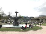
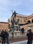 al Żigànt_The Fountain of Neptune, also known as "the Giant", is a renaissance opera that stands into Piazza Maggiore, the most important square in Bologna. It was designed to glorify the papal government (as Neptune dominates the waters, so the Pope dominates the world). It is currently one of the most famous and recognized symbols of the city.
 -
 La Grassa_ Capital of a region of great culinary passions, Bologna is associated with the imaginary perception of the city as a paradise for food delicacies. Traditional local specialty shops are the perfect example of Bolognese hedonism.
![Bologna città [W]etropolitana_Not a subway access, but a sign of artistic performances that took place in those spaces and that has become part of a stratified landscape. A modern monument that represents the aesthetics of the provisional, infiltrates our landscape in a work of continuous adaptation, with a tangible subliminal act plausible enough to become familiar and mimically incorporated.](/index.php?title=File:1_Wetropolitana.jpg)


Landscape Symbols Auther 3: Seyed Amir Hosseini Shahrestani
-
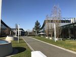 Roof garden of Exhibition hall Stuttgart.The place which people can take rest from chaos of Exhibition hall, to get together, talk and know each other. most of the time people contact each other after a short conversation. I would like to name this place ‘’the place of socializing and business’’. 48.693282, 9.186010
 -
 Main Square of Stuttgart. The spring, the time to go out and feel like birds, to chat, to make conversation, to look at the nature which is trying to be alive again, to feel it, to do the same ‘’being Alive Again’’. Happiness, green and free spaces. 48.778679, 9.180055
 -
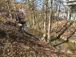 Nürtingen. Be river, never stop, be bless for your path and around, and get bless from your path. Give live and take it in other way. 48.627918, 9.345074


Landscape Symbols Author 4: Nahian Zobaid
<gallery caption=" " widths="150px" heights="150px" perrow="5"> File:12963763 10156738107310133 2790535050829475682 n.jpg|This photograph clicked by me in Bangladesh. As we know that Bangladesh is a riverine country and it is very common to get new land (river sand bed / Char) in the river. Sometimes some of these new lands last for long and sometimes some of those vanish in a short time. As a agricultural country (Bangladesh) most of the country men are farmers and when they see that there are little bit green (like the photograph) on the river sand bed / char, then they get hope to get new agricultural land. These green are the symbol of hope for these farmers. Geo-location 20'34N to 26'38N latitude, 88'01E to 92'41E longitude
<gallery caption=" " widths="150px" heights="150px" perrow="5"> File:Swadhinata Stambha.jpeg |The main attraction of the Swadhinata Stambha is the Stambha / monument itself. Stambha means pillar or tower in Bengali. The tower was built on the place where the commander-in-chief of East Pakistan Army Amir Abdullah Khan Niazi signed the papers of his surrender. During night, the tower looks elegant as the rays of light come out from every single inches of the tower. The whole tower turns into a white pillar. The tower is square according to the plan and is 16 feet wide from every side with an area of 64 inches. The underground museum of the project comprises several photographs with historical significance. There are a number of terracotta murals on war-heroes and the events of the Liberation War, a 2000-seat auditorium, and an open-air theater. The eternal flame stands beside the tower. The water body of the project reflects the whole tower all the day and increases the beauty of the project. But the water body is under potential threat as the local slum-dwellers use it for their daily needs. This monument is representing the past , present and future of Bangladesh at a time. Geo location: 23°42′N 90°22′E
<gallery caption=" " widths="150px" heights="150px" perrow="5"> File:Ratargul, Sylhet.jpeg|In this picture, we can see the water channels in land. The place is in Sylhet, one of the district of Bangladesh. People use the boats for commuting. Also they have the access to the land but they are comfortable with the water boats. The evergreen forest is situated by the river Goain and linked with the channel Chengir Khal. Most of the trees growing here are the Millettia pinnata. The forest is submerged under 20–30 feet water in the rainy season. For the rest of the year, the water level is about 10 feet deep. Geo location: 25°00.025′N 91°58.180′E