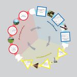
LED Online Seminar 2017 - Working Group 2
--> Back to working group overview
Dear working group members. This is your group page and you will be completing the template gradually as we move through the seminar. Good luck and enjoy your collaboration!
Assignment 1 - Reading and Synthesizing Core Terminology
- You can read more details about this assignment here
- Readings are accessible via the resources page
Step 1: Your Landscape Democracy Manifestoes
-
 Julia's manifesto
 -
 Phan's manifesto
 -
 Maythe's manifesto
 -
 Sander's manifesto
 -
 Maurizio's manifesto


Step 2: Define your readings
- Please add your readings selection for the terminology exercise before April 12:
A: Landscape and Democracy - Mapping the Terrain
- Antrop, Marc; Kühne, Olaf (2015) Concepts of Landscape, in: Landscape Culture - Culturing Landscapes. The Differentiated Construction of Landscapes (Bruns, Kühne, Schönwald, Theile ed.) (Julia)
Landscape Concepts:
- Constructing Landscape Conceptions - Kucan, Ana (Sander)
B: Concepts of Participation
- Multiple views participatory design - Henry Sanoff (Maurizio)
- The powerful, the powerless, and the experts - John Gaventa (Julia)
C: Community and Identity
- Design for ecological democracy - Hester, Randolph (Maythe)
- Culture and changing landscape structure - Nassauer, Joan Iverson (Phan)
D: Designing
- Westport Case study - Kot, Douglas and Ruggeri, Deni (Sander)
- Design Charrette: A Vehicle for Consultation or Collaboration? - Nicola Dawn Smith (Maurizio)
E: Communicating a Vision
- Reading the Landscape - Simon Bell, EMU Tartu (Maythe)
- Storytelling example from the Scottish Islands (Maurizio)
Steps 3 and 4: Concepts Selection and definition
- Each group member selects three relevant concepts derived from his/her readings and synthesize them/publish them on the wiki by April 30, 2017
- Group members reflect within their groups and define their chosen concepts into a shared definition to be posted on the wiki by May 10, 2017.
- Other group members will be able to comment on the definitions until May 20, 2017
Concepts and definitions
Author 1:
- Concept 1
- add you definition here with 2-3 concise sentences. Do not copy paste text from others, use your own words. Make reference to resources used.
- Concept 2
- .....
- Concept 3
- ....
Author 2:
- ......
- .......
- .......
Author 3: Sander
- Concept 1
- When planning on making a design for a community, listen to the residents. Find out what they want and what would improve their community life. Recourse used: Kot, Douglas and Ruggeri, Deni: Westport Case Study.
- Concept 2
- Designs should be made in order to strengthen the character of the town or community where you are designing for. It should fit in the landscape, architectural character and lifestyle of the residents in the town. Recourse used: Kot, Douglas and Ruggeri, Deni: Westport Case Study.
- Concept 3
- Keep an eye on the environment of the designing area. In order to deliver the best design, you have to find the symbolic behind the place and the residents relationship with it. On this way you can create an uniformity between the existing landscape and your design idea. Recourse used: Kucan, Ana (2007). Constructing Landscape Conceptions. In: ECLAS (ed.). JoLA spring 2007, 30-41. Munich: Callwey.
Author 4: Maythé
- ......
- .......
- .......
Author 5: Maurizio
- Concept 1 - - [Sanoff, Henry (2014): Multiple Views of Participatory Design]
- Concept 2 - - [Sanoff, Henry (2014): Multiple Views of Participatory Design]
- Concept 3 - "Voting" is a partial form of democracy - [Sanoff, Henry (2014): Multiple Views of Participatory Design]
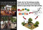
- "Voting" is a partial form of democracy. There are various ways in which to interpret the concept of consensus, from the old one of "consensus gentium" to the political one in which a majority supports a particular proposal. In any case, consensus should be reach in a concerted, stress-free manner, with dialogue and exploring different opinions. The deliberative democracy is based on the conscience of differences, the need for compromise and the growing sense of belonging. The legitimacy of a decision does not depend on its content but on the confidence in the process by which it was taken (fair, open, democratic) and the ability of citizens to play a role in defining it. In participatory processes, the satisfaction of citizens/users does not depend much on the degree to which their needs are met but rather in the feeling that they have contributed to the decision-making process.
- Concept 1 - Something about Charrette - [Smith, Nicola Dawn(2012): Design Charrette: A Vehicle for Consultation or Collaboration]
- Depending on the needs, the "Charrette" technique can be expressed in infinite ways. There are no two equal Charrettes but in all of them it is possible to recognize a common structure consisting of the following three phases: 1. Gathering information; 2. Design event; 3. Implementation. The time to use for a successful "Charrette" is at least 4 days. It is a consultation and involvement tool mainly used in the private sector of urban planning and architecture but could be used in many other areas. Among the design tools that employ drawings, mental maps, and site related graphics, the "Charrette Design" is the only one that improves the knowledge of stakeholders before converging information. The "Charrette" have the prerogative of expanding education and research. Charrette promotes internal creativity and decision-making convergence in order to generate shared outcomes and to smooth out discord.
- Concept 2 - The importance of drawing - [Smith, Nicola Dawn(2012): Design Charrette: A Vehicle for Consultation or Collaboration]
- To actively participate in a "Charrette" human qualities are fundamental rather than acquired skills, anyway in a "Charrette" is privileged the experience of those who know how to draw quickly at the last minute and manage to communicate through sketches. Drawing does not only help design, but is primarily a method of communication between the participants. Drawings generate more direct and more accessible knowledge. “Conversing with drawings is a rare skill”. The highest moment in a Charrette is when a designer reaches consensual approval through a sketch. The drawings made during a Charrette are real contracts drawn through pictures.
- Concept 3 - The importance of time - [Smith, Nicola Dawn(2012): Design Charrette: A Vehicle for Consultation or Collaboration]
- The time compression that characterizes Charrette makes the process more efficient and facilitates problem solving in a creative way because: 1)Restricts consultation between stakeholders and excludes the possibility of sterile negotiations; 2)Encourages people to "think outside the box"; 3)Maintains the survey material and the key points of the decision-making process.
- Concept 1 - - [Storytelling example from the Scottish Islands]
- Concept 2 - - [Storytelling example from the Scottish Islands]
Step 5: Reflection
- Please write, as a group, a 250 words reflection on your discourse and document it here
Step 6: Revised manifestoes
- please look again at your initial manifestoes and update them with any new aspects/prespectives you have taken up during this seminar
-
xy's updated manifesto
-
xy's updated manifesto
-
xy's updated manifesto
-
xy's updated manifesto
-
xy's updated manifesto
Assignment 2 - Your Landscape Symbols
- You can read more details about this assignment here
Landscape Symbols: Julia
-
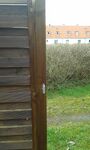 It's a fence in Germany that seperates a private garden from the surrounding landscape. It shows that there are also types of landscape which are not available for everybody.
 -
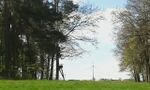
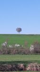 a lonely tree
 -
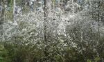 The first flowers in spring (the nature is "waking up")-the landscape shows the time of the years
 -
 A human created wind turbine (as a energy source) in the middle of natural landscape
 -
add a caption (one paragraph max) description of the symbolism, interpretation, as well as geo-location


Landscape Symbols: Duy Phan
-
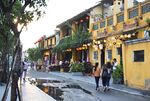 Hoi An Old Town – an ancient Beauty of Vietnam. Hoi An Ancient Town has retained its traditional wooden architecture and townscape in terms of plot size, materials, façade and roof line. A lively ancient world can survive in this new modern and high-tech era
 -
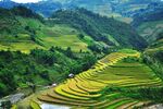 Terraced Fields- Northern mountainous region of Vietnam. Slopes claimed from nature for cultivation in hilly or mountainous areas. With it, local ethnic minority people can grow rice from the foot to nearly top of mountains.
 -
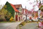 Kleinglattbach- Vaihingen an der En. A village with old and new houses mixed together.
 -
add a caption (one paragraph max) description of the symbolism, interpretation, as well as geo-location
-
add a caption (one paragraph max) description of the symbolism, interpretation, as well as geo-location


Sander's Landscape Symbols
-
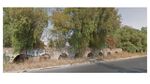
 The reconstructed Roman fort entrance in Welzheim is part of an enormous 550km long defence wall with look-outs, forts,.. that defined the border of the upper germanic limes. This part of the UNESCO World Heritage gives us a look at the rich history our world has known. It shows us the way people lived ages ago, and gives us the opportunity to pass this knowledge and history to others. Location: Welzheim, Germany. Geo-location: 48°52'17.4"N 9°38'29.1"E
 -
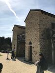
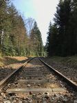 This old, 23km long railway connected till 1988 a few villages to each other with a steamtrain passing by. These days the railway is only being used as tourist attraction. During the summer months a steam train rides the 23km rails. This tourist attraction keeps the link between the history alive and makes sure the railway stays in good condition. This way of bringing alive of heritage gives the city of Welzheim an extra option in developping its city. Location: Welzheim, Germany. Geo-location: 48°51'50.9"N 9°38'21.0"E
 -
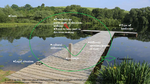
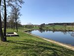 The Lake is a loved place for people living in the surroundings to spend a few hours during nice days. It allows you to get in contact with people or to meet new people. Such public places are important places to get social contact and get out of the cities. Location: Welzheim, Germany. Geo-location: 48°54'06.1"N 9°38'17.2"E
 -
add a caption (one paragraph max) description of the symbolism, interpretation, as well as geo-location
-
add a caption (one paragraph max) description of the symbolism, interpretation, as well as geo-location


Landscape Symbol: Maythé García Velarde
-
 This is the Aqueduct of Guadalupe that is located in the north area of Mexico. Is a hydraulic work of the epoch novohispana, that was conected to different towns to provide water.
 -
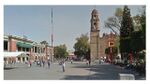 This is the center of one municipality in Mexico, the church next to it it was costructed in the 1964. We can appreciate the two powers in a public space.
 -
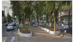 In the 1961 this pedastrian way was developed with the idea of creating new areas for the public.
 -
add a caption (one paragraph max) description of the symbolism, interpretation, as well as geo-location
-
add a caption (one paragraph max) description of the symbolism, interpretation, as well as geo-location


Maurizio.b's Landscape Symbols
-
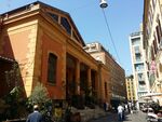
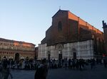 The unfinished Basilica of San Petronio is the sixth largest church in Europe (it is the largest brick Gothic church). The Episcopal Church of Bologna is not San Petronio but the near Saint Peter's Cathedral. The construction started in 1390 under the supervision of the architect Antonio di Vincenzo. In 1514 there was a new project by Aruino degli Arriguzzi. The Basilica had to become bigger than St. Peter's in Rome, but Pope Pio IX requested to build "Archiginnasio" (the university library) 12 meters far from the church and its construction had to stop. The building was built for civic will, not ecclesiastical. It was an act of religious faith but above all political. It is a monument that represents municipal ideals of freedom and authonomy. Localization: 44°29'36.5"N 11°20'35.2"E
 -
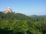 The hills of Bologna, the green belt of the city, are surely one of the most significant symbol. They ensured the livelihood of Bologna since ancient times; noble families used to pass their holiday in villas on the hills and little towns were born through the ages. Right next to the "Gothic line", the hills had been of help to partisans and allied to take refuge, in fact, the land is littered with memorial monuments. Nowadays besides the production of wine and other food excellences, the hills are one of the main places of leisure for all the citizens. Localization: 44°18'10.0"N 11°12'49.6"E
 -
 The railway station of Bologna is one of the most important italian railways in number of passengers and above all for passing trains. It is the principal railway linking node between north and south. The first project, dating from the middle of the XIX century, turned out to be unsuitable for the excessive trains congestion. The present railway was designed by Gaetano Ratti and opened in the 1871. Continuous improvements and expansion have been necessary and the process is still ongoing. The railway represent a symbol for the city not only for its practical aim but overall for the most serious act of terror that occurred in Italy in the second post-war period, on the 2nd of august 1980 at 10:25 am. This is considered one of the last act of the strategy of terror (Years of Lead). Localization: 44°30'20.7"N 11°20'36.1"E
 -
 The “Mercato delle erbe”, literally “Market of herbs”, is the largest covered market in the historical center of Bologna, since 1910. It was built to offer shelter to the merchants that could no longer stay in Piazza Maggiore (the most renowned square in the city). Since 2014, in addition to the presence of merchants that sell typical products or food, after renovation of some spaces in the market, there are inside the building also restaurants, bars, pizza restaurants and sandwich shops. In the “Mercato delle erbe” you can touch the historical gastronomical culture of Bologna. I’ve chosen this place mainly to highlight how similar reality nowadays must increasingly deal with supermarket and commercial center perhaps more comfortable but less related to the context and the history of the site. Localization: 44°29'46.0"N 11°20'21.8"E
 -
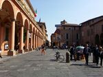 Via Zamboni connecting the two towers to medieval city gate named San Donato passes through the university area. Like most of the streets of the old town it is full of historical buildings of the Middle Ages, commemorative plaques and monuments that recall the past of the city. However, what distinguishes this way is the presence of many of the seats of the faculties of Alma Mater Studiorum (Founded in A.D. 1088, it is the oldest university in Europe). The constant presence of the students makes via Zamboni particularly lively all day long. In my opinion, thanks to the presence of more than 87,000 young students of the Alma Mater Studiorum, the Bolognese citizens have unknowingly the ability to keep open their minds. Localization: 44°29'46.3"N 11°21'01.7"E


Assignment 3 - Role Play on Landscape Democracy "movers and shakers"
- You can read more details about this assignment here
Assignment 4 - Your Landscape Democracy Challenge
- You can read more details about this assignment here
- Each group member will specify a landscape democracy challenge in his/her environment
Landscape Democracy Challenge 1
- Give a title to your challenge
-
caption: why did you select this case?
-
caption: what is the issue/conflict (1)
-
caption: what is the issue/conflict (2)
-
caption: who are the actors?
Your references:
- ...
- ...
Landscape Democracy Challenge 2
- Give a title to your challenge
-
caption: why did you select this case?
-
caption: what is the issue/conflict (1)
-
caption: what is the issue/conflict (2)
-
caption: who are the actors?
Your references:
- ...
- ...
Landscape Democracy Challenge 3
- Give a title to your challenge
-
caption: why did you select this case?
-
caption: what is the issue/conflict (1)
-
caption: what is the issue/conflict (2)
-
caption: who are the actors?
Your references:
- ...
- ...
Landscape Democracy Challenge 4
- Give a title to your challenge
-
caption: why did you select this case?
-
caption: what is the issue/conflict (1)
-
caption: what is the issue/conflict (2)
-
caption: who are the actors?
Your references:
- ...
- ...
Landscape Democracy Challenge 5
- Give a title to your challenge
-
caption: why did you select this case?
-
caption: what is the issue/conflict (1)
-
caption: what is the issue/conflict (2)
-
caption: who are the actors?
Your references:
- ...
- ...
Assignment 5 - Your Democratic Change Process
- You can read more details about this assignment here
- After documenting and reflecting on your challenges you will continue jointly with one of these challenges and design a democratic change process
Your Democratic Change Process
- Add the title of your project
-
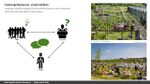
a power map identifying who is affected by the challenge and who is influencing it
-
Look at the various methods and tools available and think how they can be applied creatively. Think about the needs of different stakeholder groups - you may need a methodical mix to address them all. Illustrate graphically how these methods/tools might be applied in a short, medium and long-term perspective.
-
a scenario illustrating how these tools can be applied within a short, medium and long term perspective involving the groups you want to address, this should include a process timeline
.jpg)
Reflection
- Evaluate in the group how far your ideas either built on the theoretical frame that has been introduced to you during this seminar or react to this by filling a potential gap (approx 150 words)
Your references
- ....
- ....
- ....
- ....