Freising-Moosach Landscape Democracy 2022 Team 1
>>>back to working groups overview
For help with editing this Wiki page use this link.
For more details on assignments and key readings please use this link.
| Area | Upper Bayern | |
| Place | Freising | |
| Country | Germany | |
| Topics | Landscape Democracy | |
| Author(s) | Agata Ziobrowska, Christopher Samuel Lahaye, Evelina Saveleva and Maria Beatriz Guedes Quintella, Sahar Esmaeilian | |

| ||
| 05.04.2022 | Survey of residents | |
Landscape Democracy Rationale
The population changes of the Munich periphery between the years 1990 and 2015 represented to the region an intense urbanization process. The emergence of new commercial and economic attractions encourages migration to the city and stimulates the growth not only of the greatest urban center but of the cities around it, as well.

For example, the graph below shows how the city of Freising – a satellite city of Munich - grew in the last 180 years, and it can be observed how the numbers went up since 1987.

If the urban sprawl continues at the scale observed, the conurbation of cities can become a problem for the local landscape. The current environmental protection areas will have to be adapted., which may lead to microclimate changes, water, air, and noise pollution, putting at risk natural habitats and the local biodiversity.
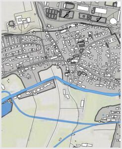
Location and Scope
- You can edit this map with the map editor
Phase A: Mapping Your Community
Welcome to Your Community and Their Landscape
- In a first moment some data available in the District Office was taken into consideration which informed that Freising is a city with approximatedly 50 thousand inhabitants. The landscape of the town is marked by two hills, the Cathedral Hill and the Weihenstephan Hill, and two rivers, the river Isar and it's tributary, the river Moosach that crosses most of the urban part. This information was useful to situate us on the place to be worked on, and to understand that for a better analysis of the situation, we should reduce the scale of observation and give the locals a voice. Therefore, the main method to identify the community was empirical observation. Therefore, it was necessary to reduce the scale of the research scope. Covering a part of the urban scale of Freising it was identified the following community members: Homeless people, local visitors, commuters, kids, tourists, elderly people, disabled people, students, families, single adults, farmers, and local politicians. Each of these members interacts in a particular way with the scenario and has individual contributions to the landscape.
-
 Scale used for analysing the community
 -
 Community in the Urban area


Groups of Actors and Stakeholders in Your Community
- In a general idea of Freising, the members of the community identified during the living lab were farmers, families, kids, single adults, students, commuters, local visitors, elderlies, disabled people, tourists, and the fauna and flora. They are distributed in the city in a non-organized way and interact with each other through mutual or opposing interests. The stakeholders are the party interested in investing in the city, aiming for some profit. Regarding the situation of Freising as one the of most urbanized cities in Bavaria, the local stakeholders identified were farmers, hospitals, local universities, schools, landlords, city council, hostels owners, city commerce, and the external stakeholders – that can be part of the local stakeholders – are hotel owners, scholars/ experts, legislators, tourists, and social/ environmental activists. All stakeholders have specific interests in the city and the community members, thus, creating individual relationships with each of them. The following maps illustrate their relationship and interests.


Relationships Between Your Actors and Groups
- Identifying interests is crucial to comprehend whether the relationship is positive or negative between the actors and the groups. Therefore, the groups were organized in order of dominance of power and voice over the community arrangement. The following conceptual maps illustrate the communities, their interests, and their power relation:


Summary of Your Learnings from the Transnational Discussion Panel
- As a group we acknowledge that there was some differeces between the results of the mapping mainly because of the diverse national context we are working on. It was also very insightful to see how different cultures approached the comunity, and worked on their landscape. Regarding our situation, we decided to dig deeper in the economic aproach and power incluence we observed, so we can better understand the relationship between the locals and the farms - which we considered the most powerful economic factor influencing in Freising.
Theory Reflection
- Landscape democracy is a good clue for landscape architects.
- Firstly, to understand the unique local communities, which play an enormous role in creating the future project.
- The second step is identifying the relationships between communities. This output clarifies the future scenario. Moreover, it helps to create positive connections through the planning design, for example, back to our community map how we can improve the relationship between environmentalists and owners of a fish farm through our future scenario.What function we can create in the concept of this two positively. This principle gives a lot of insight into our work. This way of thinking gives a significant output, which helps not ignore any community and keep the focus on it during the work.
References
- Views of the world. Changing demographies of Germany. October 3, 2012. Available at: < https://www.viewsoftheworld.net/?p=2719 >
- Bayerisches Landesamt für Statistik. Große kreisstadt Freising [178 124|09 178 124]. Statistik kommunal 2021. Available at: <https://www.statistik.bayern.de/mam/produkte/statistik_kommunal/2021/09178124.pdf>
Phase B: Democratic Landscape Analysis and Assessment
Agata Ziobrowska: Attachment
-
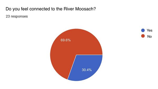 During the survey of Freising residents the most frequent answer to the question whether they feel connected to the Moosach River was: no. This shows a lack of attachment or interest in the fate of this place.
 -
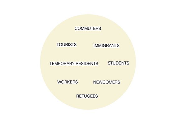 Lack of attachment may be related to the fact that there are various community groups that are not originally from Freising. Many groups are here temporarily, in connection with work or studies or their stay has a political-economic background.


Sahar Esmaeilian
-
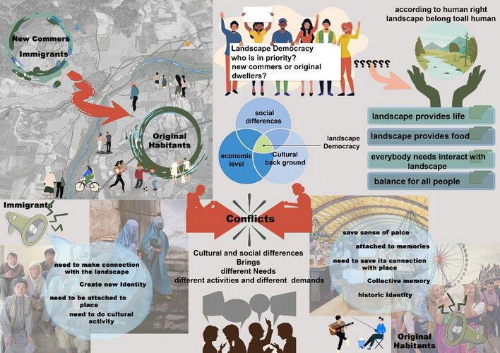 As new comer to Freising my first challenge was making connection with city both as new dweller then as landscape architecture student. This process made me to spend a great deal of time in the site to stroll in. At first as an English speaker it was so difficult to make connection but it also helped me to see other part of stakeholders as immigrants who are part of this society which have different culture, back ground and need to attach to new place. Afghani people are part of immigrant’s society which live in freising and they have their own society. They need to attach to this city and make contraction with social spaces as Moosach and Isar River but in some cases their needs are not in same direction with original city dwellers. For example most city dwellers look at moosach as a calm place for rest and fishing while in the culture of Afghani people have picnic, outdoor cooking and gathering around river is part of their cultural need and a way to make connection with landscape. As landscape architect new big question came to my mind which group must be in priority? Any action I do maybe destroy some part of collective memory of original city dwellers or can create opportunity for new comers to attach to landscape. As attachment is part of the process to insure people would care about landscape in future. What action must be taken by a landscape Architect do when the conflicts between stakeholders emerge? The answer I found is according to landscape democracy, nature and built environment both belong to all human and each should respect to other needs. Landscape architect must create balance to make justice in social and cultural heritage and connection.

Maria Beatriz Guedes Quintella: where is the stimuli?

During the discussion with my reading partner, I notice that maybe the problem with the community analysis and the living lab in Freising is in the lack of stimuli toward people’s participation. It is important not only to listen to people’s opinions but also stimulate participation through other stimuli, such as sound or vision. Therefore, putting in practice the transdisciplinarity and erasing boundaries as suggested in the “Community Matters” and the “Introduction at the boundaries” articles.
Evelina Saveleva personal research: Relationships between farmers and environmentalists
Evelina Saveleva and Max Götz:Participatory methods guideline


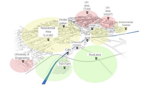
Where?
The chosen area is situated on the East side of Freising. It is a mixed territory with urban and rural sites. Here we have Universities, Hotels, cafés, and even a construction firm. Although near the river is situated an Environmental community that researches water characteristics of Moosach river.
What the problem?
Pond farms, directly release their untreated wastewater into the environment surrounding their farms. This is a serious concern, not just for the natural environment, but also for surrounding communities which often use the water from public canals for drinking, bathing and washing utensils.
How to solve it?
From the environmentalist's site, we suggest to the fish farmers:
- Applying biosecurity measures to avoid the disease.
- Land, water, and biodiversity must be protected from degradation.
- Consider using your fish pond in integration with other agricultural activities.
Christopher Samuel Lahaye El Carrito: ROLLING OUT THE CART

In the conversation with my partner we both agreed that when it comes to community analysis it is very important to catch as much attention from as much people who live in the area as possible. So I thought about the technique I read about that is called ‚EL CARRITO’. This technique is about creating a mobile interactive meeting point that catches the attention of the people as they move through their usual public spaces. It is a piece of art, that catches the attention by introducing some kind of good disturbance into a place. When the peoples attention is caught the community analysis can begin by asking them questions, let them fill out surveys, let them draw in plans, handing out flyers or have games for children. To get to all parts of the community it should be placed in different locations on different times. In the comversation we thought about what the CARRITO for Freising will need to work as best as possible and the collage above is the final result.
Phase C: Collaborative Visioning and Goal Setting
The Scene in Your Story of Visioning
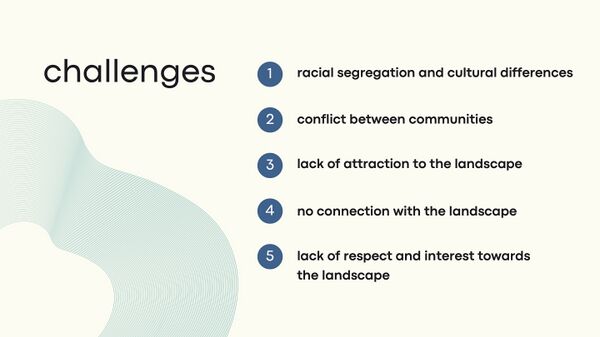
- During our observations and conclusions from everyday life living in Freising, we observed several challenges faced by certain social groups existing in the city. Freising is a traditional Bavarian city with many natives and locals. but it is also a home to people from other countries. As an international student body currently living here, we also face some challenges. One of them, for example, is the racial segregation and diversity of cultures. We observed that people of different cultures and religions feel isolated and excluded from the local community and do not always feel comfortable or welcome here. They often cannot find their own place where they can freely spend time as according to their culture and habits. They do not feel attached to the existing landscape, nor do they respect it or feel interested in it. Possibly their local landscape is closer to them and they feel a bond and connection to it. In some places in Freising you can observe how other cultures form closed social groups practice their cultural values in the open space.
-
 Landscape democracy challenges in our scene
 -
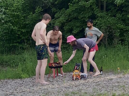 Group of internationals doing BBQ in a park in Pulling (near Freising)


The Actors in Your Story of Visioning
- We identified communities that are involved in our landscape democracy challenge and divided them into 4 groups: newcomers, local citizens, nature and local government. The newcomers are those who are not originally from Freising and their stay here is related to a matter of study, politics, work or simply in search of a better life. Local citizens make up the largest part of the local population and do not integrate very well with newcomers. Nature also plays a very important role because we observe how other groups behave towards it. how it is perceived and how they use its qualities. The final actor is the local government, which is the intermediary between groups of people and nature. its decisions can positively or negatively influence the interaction between these groups.
-
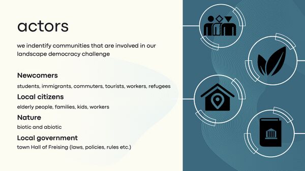 Actors in ours scene

The Story of Visioning
- On the grounds of observations and our own experiences, we have pointed out our goals which, if achieved, we would overcome the aforementioned challenges. In order to encourage people to take an interest in the local landscape, it might be important to stimulate people's creativity and active participation in social events. If we care about nature and its well-being and future, we should spread ecological knowledge and actively raise awareness about environmental problems. Creating new conservation areas is a good solution as well as new laws and regulations for nature and human participation in the landscape.
- To achieve our goal we created a vision for the future that would support our concept for the green areas in Freising. Our aims are: creativity, diversity, interactivity and equality.
- Based on our goals and vision, we have set out actions and created an overall plan for 3 years. The first year is dedicated to the creation of laws and new regulations such as the possibility for immigrants, refugees and tourists to have a say in the creation of new green public spaces. Besides, it is important to start the process of creating new conservation areas. Year two will be the beginning of the planning process and the implementation of sustainable and equal solutions in design. An important event will be public participation meetings in which everyone will be able to take part and cast a vote, submit an idea or be creative. In the third year, plans will go into effect and project implementation and finalization will start. There will be interactive events and open space attractions and an intensive environmental education program will begin.
-
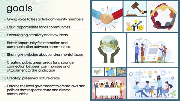 Our goals for more human-nature integration in the future of Freising
 -
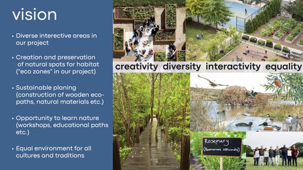 Our vision is a way to achieve all the goals
 -
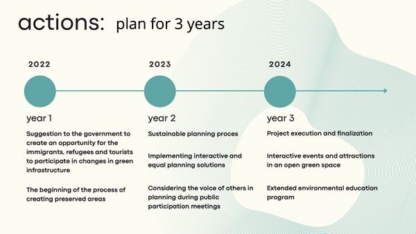 Actions: plan for 3 years


Reflect on Your Story of Visioning
- In developing our goals, we have found it important to take these characteristics into account: voice of people, environmental condition, future perspective, past experience, laws and policies.
- Our vision corresponds to our goals. We believe that a good vision is one that is high-quality, sustainable, equal and reflects the identity of the place.
-
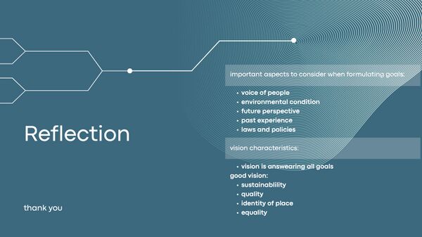 Reflection on our goals and visions

Phase D: Collaborative Design, Transformation and Planning
Your Prototyping Action
- insert text here
-
insert text here
-
insert text here
-
insert text here
The Evolution of Your Prototyping Action
- insert text here
-
insert text here
-
insert text here
-
insert text here
The Plan Behind Your Prototyping Action
- insert text here
-
insert text here
-
insert text here
-
insert text here
The Realization of Your Prototyping Action
- insert text here
-
insert text here
-
insert text here
-
insert text here
Reflect on Your Prototyping Action
- insert text here
-
insert text here
-
insert text here
-
insert text here
Phase E: Collaborative Evaluation and Future Agendas
Collaborative Evaluation and Landscape Democracy Reflection
- insert text here
-
insert text here
-
insert text here
-
insert text here
The Actors in your Collaborative Evaluation
- insert text here
-
insert text here
-
insert text here
-
insert text here
Reflection on the Online Seminar
- insert text here
-
insert text here
-
insert text here
-
insert text here
Reflection on your Living Lab Process
- insert text here
-
insert text here
-
insert text here
-
insert text here
Your Living Lab Code of Conduct
- insert text here
-
insert text here
-
insert text here
-
insert text here
Process Reflection
- insert text here