Freising-Moosach Landscape Democracy 2022 Team 4
>>>back to working groups overview
For help with editing this Wiki page use this link.
For more details on assignments and key readings please use this link.
| Area | Moosach River | |
| Place | Freising, Bavaria | |
| Country | Germany | |
| Topics | ||
| Author(s) | Ana Cristina Gonzalez, Ayse Dolanbay, Joshua Peterson, Nanna Hardardottir, Shyam Chaudhari | |

| ||
Landscape Democracy Rationale
We are focusing especially on the rural areas outside of Freising. Based on accounts of how cooperation with farms is key to successful implementation of new policies for environmental protection, we hypothesize that the key landscape democracy challenge will be uniting farmers with people in the city of Freising in completing mutually beneficial projects in the Moosach waterscape.
Location and Scope

Phase A: Mapping Your Community
Welcome to Your Community and Their Landscape
Our community is located in Upper Bavaria, north of Munich in the town of Freising and surrounding areas.
The Moosach River is our main focus for this project. It is 38 kilometers long and runs parallel to the borders of the Munich gravel plain.
Freising is a middle and working class community that is greatly shaped by its proximity to a large international airport and the city of Munich. The campuses of HSWT and TUM mean there is a proportionally high number of young people.
Munich’s growth has put pressures on the real estate market and regional transportation. We wanted to look deeper into how it will grow and what ways this might influence development in the area in the future.
The projected continued growth of Munich will lead to increased spillover into the surrounding areas, including between Unterschleißheim and Freising which encompasses the Moosach. Looking at projected jobs, we can see that industries like manufacturing are not expected to increase, but information and service sectors will. We will use this information to hypothesize about the types of land use we might see expanding in the future around Freising, and how this might change the community of our project area.
Groups of Actors and Stakeholders in Your Communi
We researched businesses, planning entities, nature groups, and others, and plotted them according to their importance, and then again according to their power.
-
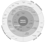 Stakeholders Map
 -


Relationships Between Your Actors and Groups
-
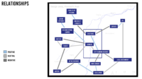 Key groups are in the center of this map

Summary of Your Learnings from the Transnational Discussion Panel
One main point of feedback was that “importance” is too ambiguous to evaluate stakeholders by. Rather, it would be better to still evaluate them by their amount of power, like we have done, but also by their potential impact on the Moosach waterscape. Then, it is also beneficial to proceed with a power map, where you chart their level of power vs impact.
We also discussed social groups vs stakeholders. Social groups are more abstract demographic segments of a population, while stakeholders are specific entities which have a structure or organization through which they act on their environments. It is useful to map them together as we have done, so that their impact and relationships can be considered together, but we should also recognize that they each operate differently. Often social groups need corresponding stakeholders through which to act, and if we wanted to involve a social group through participatory design we may need to identify stakeholders through which to engage them as well.
Theory Reflection
In the reading “Historical Developments: “The Evolution of the Concept of Landscape in German Linguistic Areas,” Olaf Kuehne, charts how the meaning of “Land” has changed through time. In the beginning it was described as a state or legal territory and as the buildable surface of the earth. Landscape might be considered an aesthetic issue, to be approached through things like painting. Today the European Landscape Convention has defined landscape as a “part of the land, as perceived by local people or visitors, which evolves through time as a result of being acted upon by natural forces and human beings.”
We used these texts to help think through how the Moosach landscape includes all the people who live on and use the land, and how our work can include these people.
To that end, we also read Transformative Science. If you take the framework of transformative science and substitute in the word “design,” transformative design similarly describes an orientation towards involving stakeholders as much as possible. It also describes much of the approach to learning we are taking in this class, in trying to situate as much of our research and design work as much in the realities of our project’s community as possible, involving real people who live there in our work.
References
- https://www.sueddeutsche.de/muenchen/freising/freisinger-moos-moor-umweltschutz-1.5225243
- https://www.sueddeutsche.de/muenchen/landkreismuenchen/klimaschutz-etwas-moos-fuers-moos-1.5450603
- https://stadt.muenchen.de/infos/wirtschaftsfoerderung.html
- https://www.wirtschaft-muenchen.de/produkt/erwerbstaetigenprognose-muenchen-bis-2030-kurzfassung/
- https://www.wirtschaft-muenchen.de/produkt/real-estate-market-report-munich-2022-2023/
- https://de-statista-com.libdata2015.hilbert.edu/statistik/daten/studie/1885/umfrage/mietpreise-in-den-groessten-staedten-deutschlands/
Phase B: Democratic Landscape Analysis and Assessment
Ana Cristina González García "Forgotten Moosach"


During the years we lost connection to our surroundings and nature, starting to forget as well. Everyday I walk from the train station to university, in some parts I need to cross bridges or walk very close to the water, one day I realized the river was becoming invisible for me, making me feel very disconnected to it. I realized by observing the dynamic of the place that people in general felt the same. With this collage I want to represent how older generation were far more connected to the water, hoping that with our projects we can encourage people to reconnect with Moosach.
Nanna Vilborg Harðardóttir "No to Aquaculture"
-
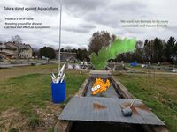 Taking a stand against aquaculture
 -
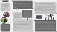 Nanna and Mary's readings and thoughts


Ayse Dolanbay "Buffer zones around Moosach"


We want to make bigger buffer zones with vegetation to protect the rivers from the fertilizer the farmers are using for their fields.
Protection and Expansion of the vegetation are the key words. With that the water quality can improve and the biodiversity in and around the river can grow.
Josh Peterson "We're almost there!"


During a chance conversation with a shop owner, they mentioned that their business was struggling due to construction on our project river.
On Freising’s main street, a pedestrian historical street that serves as the center of shopping and in many ways public life in the town, for the past three years the city has been uncovering a section of the Moosach River that was previously a closed canal. Once the project is finished, a presumably beautiful and quaint water feature will be at the center of this center. Steps along the river will let people sit, have a coffee, and relax together as they watch the fish go by.
In the meantime, however, some local businesses in the area are struggling due to the disruption from construction. The shop owner I spoke with said that the city has kept extending the project, and he didn’t know when it was planned to end.
For my analysis, I decided to speak to more shop workers to see what their sentiments were. My reasons were:
- Curiosity about how widespread these frustrations with the project may be
- Learn more about potential negative impacts of landscape projects
- Learn something about how the politics of the town function
- To discover strategies for gaining local expertise through conversation
- My belief that planners should seek to understand those most affected by their work, including when they are negatively affected
I do not have any particular affinity towards business owners, or feel that they should have exalted status in local governance. During COVID, in the United States their outsized political influence was counterproductive to public health (and perhaps to their own self-interest!) because it often prevented containment measures from being effectively implemented. Still, in this case they are experiencing some hardship, and it raises the question of whether the city could do anything better to support them, especially since the project has run so late past schedule.
I set out to talk to more shop owners and workers, went on to have 3 further conversations.
I prepared a few questions:
- Hat Ihr Geschäft durch das Projekt gelitten?
- Gab es Ihrer Meinung nach etwas, was die Stadt anders machen könnte?
- Können Sie sich vorstellen, wie die Stadt Sie in den Prozess einbeziehen könnte?
- Haben Sie jemals mit anderen Geschäftsinhabern darüber gesprochen?
I did not make it to questions 3 and 4 ever because it seemed like reaching, based on my intuited comfortability in the conversation. My experiment is hard to call a success because the information I got out of it was very narrow, but I’ll explain what I heard.
1. Outdoor recreation shop. Spoke in English. Said business was actually not impacted. Said it will be a nice thing once it’s done.
2. Stationary store. Spoke in German. Employee. It's a little quieter, but also more so because of COVID. Doesn't know anything the city could do better.
3. Bakery, German. Employee. It's suffered some in some times of the day, but not others. Can't really say if there's anything else the city could do.
It is interesting that their opinions about whether their business was affected were all over the map between the four of them, but that all of them did not know of anything the city could do better.
I feel that the conversations suffered because of several things which made them awkward. They were people at work who were being presented with an unusual and unexpected ask. My German is not fluent. I approached by saying I study urban planning and am interested in asking them a couple questions, which worked to quickly start things but produced the opposite of the comfortable, forthcoming conversation with the initial shopowner.
The next day, I also went on a participatory design excursion with some of my classmates along the river. Contextual factors here brought about some conversations where I learned more. I happened to speak to one person who had studied the city of Munich’s communication strategy during their ambitious Isar river restoration in completed over 2000-2011. Some people noted that they didn’t know when this project was supposed to end, or what it would even look like. It got me thinking about how even if the city wouldn’t give businesses money during the project, they could at least give them more information.
My political/moral challenge:
People may be negatively impacted by landscape projects, and they may not be included in the proces
My stance:
Those most impacted should be included especially.
My call to action:
Structures and processes for participation need to be cultivated and integrated into planning processes.
I concluded that communication from the city about the project was lacking, so I made a proof of concept poster declaring that the project is almost finished and directing people to a website where they can find more info.
Shyam Chaudhari " WATER MATTERS"
The video link - https://drive.google.com/file/d/1bQ_qs63Z5yWN8H6Q4wsmYJTPcJLySwM2/view?usp=drivesdk
During a tour along the Moosach river in Freising, I became aware of the state of the water. We all need water for a better life and that goes without saying, but fresh, clean water is essential for the survival of humans and nature. The Moosach is a valuable source of fresh drinking water for people throughout Fresing. When rivers are so polluted by industry or unevenly distributed by poor water management, it can lead to an unhealthy habitat. The Moosach is home to some of the most diverse and endangered species of animals, birds, plants and they are vital to people. Freshwater habitats are among the most biodiverse in the world, and rivers are a vital, living ecosystem for many species. People depend on rivers for their way of life and livelihood. From fishing to agriculture, the way we manage our waterways has a direct impact on people’s lives.
We also visited the main street of Freising, where the Moosach has been newly preserved and developed so that people can walk closer to the water and experience the flowing water. We collected some interviews with people about what they are actually looking for. And it was a great reaction from them that they really wanted to see the true beauty of the Moosach with the fish and the birds living a happy life. They are also looking for some water sports adventures to make the Moosach even more alive.
Phase C: Collaborative Visioning and Goal Setting
The Scene in Your Story of Visioning
- Our democracy challenge is to connect people, urban areas and the river Moosach together. The Moosach runs through large fields of agricultural land and is invisible and accessible to people in large areas. There is also a lack of larger connection routes between the urban areas that are for people only, no car traffic. There is a great path along the Isar, but that does not connect the smaller urban areas. Towns like Oberschleißheim, Unterschleißheim, Eching, Pulling and more need better connection to Freising. There is also an opportunity to connect urban areas to natural recreational areas like Pullinger Weiher, Mühlsee Badesee and Freisinger Moos. We want to fix this by adding a bicycle path that runs parallel to Moosach river and connects these areas.
-
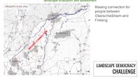 Landscape Democracy Challenge
 -


The Actors in Your Story of Visioning
- insert text here
-
insert text here
-
insert text here
-
insert text here
The Story of Visioning
- insert text here
-
insert text here
-
insert text here
-
insert text here
Reflect on Your Story of Visioning
- insert text here
-
insert text here
-
insert text here
-
insert text here
Phase D: Collaborative Design, Transformation and Planning
Your Prototyping Action
- insert text here
-
insert text here
-
insert text here
-
insert text here
The Evolution of Your Prototyping Action
- insert text here
-
insert text here
-
insert text here
-
insert text here
The Plan Behind Your Prototyping Action
- insert text here
-
insert text here
-
insert text here
-
insert text here
The Realization of Your Prototyping Action
- insert text here
-
insert text here
-
insert text here
-
insert text here
Reflect on Your Prototyping Action
- insert text here
-
insert text here
-
insert text here
-
insert text here
Phase E: Collaborative Evaluation and Future Agendas
Collaborative Evaluation and Landscape Democracy Reflection
- insert text here
-
insert text here
-
insert text here
-
insert text here
The Actors in your Collaborative Evaluation
- insert text here
-
insert text here
-
insert text here
-
insert text here
Reflection on the Online Seminar
- insert text here
-
insert text here
-
insert text here
-
insert text here
Reflection on your Living Lab Process
- insert text here
-
insert text here
-
insert text here
-
insert text here
Your Living Lab Code of Conduct
- insert text here
-
insert text here
-
insert text here
-
insert text here
Process Reflection
- insert text here