Freising-Moosach Landscape Democracy 2022 Team 4
>>>back to working groups overview
For help with editing this Wiki page use this link.
For more details on assignments and key readings please use this link.
| Area | Moosach River | |
| Place | Freising, Bavaria | |
| Country | Germany | |
| Topics | ||
| Author(s) | Ana Cristina Gonzalez, Ayse Dolanbay, Joshua Peterson, Nanna Hardardottir, Shyam Chaudhari | |

| ||
Landscape Democracy Rationale
We are focusing especially on the rural areas outside of Freising. Based on accounts of how cooperation with farms is key to successful implementation of new policies for environmental protection, we hypothesize that the key landscape democracy challenge will be uniting farmers with people in the city of Freising in completing mutually beneficial projects in the Moosach waterscape.
Location and Scope

Phase A: Mapping Your Community
Welcome to Your Community and Their Landscape
Our community is located in Upper Bavaria, north of Munich in the town of Freising and surrounding areas.
The Moosach River is our main focus for this project. It is 38 kilometers long and runs parallel to the borders of the Munich gravel plain.
Freising is a middle and working class community that is greatly shaped by its proximity to a large international airport and the city of Munich. The campuses of HSWT and TUM mean there is a proportionally high number of young people.
Munich’s growth has put pressures on the real estate market and regional transportation. We wanted to look deeper into how it will grow and what ways this might influence development in the area in the future.
The projected continued growth of Munich will lead to increased spillover into the surrounding areas, including between Unterschleißheim and Freising which encompasses the Moosach. Looking at projected jobs, we can see that industries like manufacturing are not expected to increase, but information and service sectors will. We will use this information to hypothesize about the types of land use we might see expanding in the future around Freising, and how this might change the community of our project area.
Groups of Actors and Stakeholders in Your Communi
We researched businesses, planning entities, nature groups, and others, and plotted them according to their importance, and then again according to their power.
-
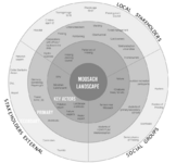 Stakeholders Map
 -


Relationships Between Your Actors and Groups
-
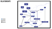 Key groups are in the center of this map

Summary of Your Learnings from the Transnational Discussion Panel
One main point of feedback was that “importance” is too ambiguous to evaluate stakeholders by. Rather, it would be better to still evaluate them by their amount of power, like we have done, but also by their potential impact on the Moosach waterscape. Then, it is also beneficial to proceed with a power map, where you chart their level of power vs impact.
We also discussed social groups vs stakeholders. Social groups are more abstract demographic segments of a population, while stakeholders are specific entities which have a structure or organization through which they act on their environments. It is useful to map them together as we have done, so that their impact and relationships can be considered together, but we should also recognize that they each operate differently. Often social groups need corresponding stakeholders through which to act, and if we wanted to involve a social group through participatory design we may need to identify stakeholders through which to engage them as well.
Theory Reflection
In the reading “Historical Developments: “The Evolution of the Concept of Landscape in German Linguistic Areas,” Olaf Kuehne, charts how the meaning of “Land” has changed through time. In the beginning it was described as a state or legal territory and as the buildable surface of the earth. Landscape might be considered an aesthetic issue, to be approached through things like painting. Today the European Landscape Convention has defined landscape as a “part of the land, as perceived by local people or visitors, which evolves through time as a result of being acted upon by natural forces and human beings.”
We used these texts to help think through how the Moosach landscape includes all the people who live on and use the land, and how our work can include these people.
To that end, we also read Transformative Science. If you take the framework of transformative science and substitute in the word “design,” transformative design similarly describes an orientation towards involving stakeholders as much as possible. It also describes much of the approach to learning we are taking in this class, in trying to situate as much of our research and design work as much in the realities of our project’s community as possible, involving real people who live there in our work.
References
- https://www.sueddeutsche.de/muenchen/freising/freisinger-moos-moor-umweltschutz-1.5225243
- https://www.sueddeutsche.de/muenchen/landkreismuenchen/klimaschutz-etwas-moos-fuers-moos-1.5450603
- https://stadt.muenchen.de/infos/wirtschaftsfoerderung.html
- https://www.wirtschaft-muenchen.de/produkt/erwerbstaetigenprognose-muenchen-bis-2030-kurzfassung/
- https://www.wirtschaft-muenchen.de/produkt/real-estate-market-report-munich-2022-2023/
- https://de-statista-com.libdata2015.hilbert.edu/statistik/daten/studie/1885/umfrage/mietpreise-in-den-groessten-staedten-deutschlands/
Phase B: Democratic Landscape Analysis and Assessment
Ana Cristina González García "Forgotten Moosach"


During the years we lost connection to our surroundings and nature, starting to forget as well. Everyday I walk from the train station to university, in some parts I need to cross bridges or walk very close to the water, one day I realized the river was becoming invisible for me, making me feel very disconnected to it. I realized by observing the dynamic of the place that people in general felt the same. With this collage I want to represent how older generation were far more connected to the water, hoping that with our projects we can encourage people to reconnect with Moosach.
Nanna Vilborg Harðardóttir "No to Aquaculture"
-
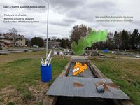 Taking a stand against aquaculture
 -
 Nanna and Mary's readings and thoughts


Ayse Dolanbay "Buffer zones around Moosach"


We want to make bigger buffer zones with vegetation to protect the rivers from the fertilizer the farmers are using for their fields.
Protection and Expansion of the vegetation are the key words. With that the water quality can improve and the biodiversity in and around the river can grow.
Josh Peterson "We're almost there!"

Your Name and title of your personal analysis
-
insert text here
-
insert text here
Phase C: Collaborative Visioning and Goal Setting
The Scene in Your Story of Visioning
- insert text here
-
insert text here
-
insert text here
-
insert text here
The Actors in Your Story of Visioning
- insert text here
-
insert text here
-
insert text here
-
insert text here
The Story of Visioning
- insert text here
-
insert text here
-
insert text here
-
insert text here
Reflect on Your Story of Visioning
- insert text here
-
insert text here
-
insert text here
-
insert text here
Phase D: Collaborative Design, Transformation and Planning
Your Prototyping Action
- insert text here
-
insert text here
-
insert text here
-
insert text here
The Evolution of Your Prototyping Action
- insert text here
-
insert text here
-
insert text here
-
insert text here
The Plan Behind Your Prototyping Action
- insert text here
-
insert text here
-
insert text here
-
insert text here
The Realization of Your Prototyping Action
- insert text here
-
insert text here
-
insert text here
-
insert text here
Reflect on Your Prototyping Action
- insert text here
-
insert text here
-
insert text here
-
insert text here
Phase E: Collaborative Evaluation and Future Agendas
Collaborative Evaluation and Landscape Democracy Reflection
- insert text here
-
insert text here
-
insert text here
-
insert text here
The Actors in your Collaborative Evaluation
- insert text here
-
insert text here
-
insert text here
-
insert text here
Reflection on the Online Seminar
- insert text here
-
insert text here
-
insert text here
-
insert text here
Reflection on your Living Lab Process
- insert text here
-
insert text here
-
insert text here
-
insert text here
Your Living Lab Code of Conduct
- insert text here
-
insert text here
-
insert text here
-
insert text here
Process Reflection
- insert text here