Democratic Landscape Transformation 2025 - Team 4: Difference between revisions
| (One intermediate revision by the same user not shown) | |||
| Line 109: | Line 109: | ||
File:Nyaz Othman.jpg|This map shows that transforming landscapes democratically isn’t just about design or nature ...................... it’s about justice, identity, voice, and inclusion. (NYAZ) | File:Nyaz Othman.jpg|This map shows that transforming landscapes democratically isn’t just about design or nature ...................... it’s about justice, identity, voice, and inclusion. (NYAZ) | ||
File:Index.php?title=File-Index.php?title=File-Index.php?title=File-Index.php?title=File-Teresa concept map.jpg|Teresa - Democratic Landscape Transformation - Concept Map | File:Index.php?title=File-Index.php?title=File-Index.php?title=File-Index.php?title=File-Teresa concept map.jpg|Teresa - Democratic Landscape Transformation - Concept Map | ||
File:Daniel Okumu - Concept.map IMLA.png|Daniel Okumu - comcept.map-IMLA | |||
File:Screenshot 2025-07-20 155548.png|Mark Kristofer R. Fajardo - Democratice Landscape Transformation Map | File:Screenshot 2025-07-20 155548.png|Mark Kristofer R. Fajardo - Democratice Landscape Transformation Map | ||
File:Integrated-map-core-pillars.jpg|Integrated teamwork map | |||
</gallery> | </gallery> | ||
Latest revision as of 14:05, 28 July 2025
>>> Back to working group overview
>>> Back to seminar reading list, session materials & recordings
>>> go to the Editing Help
Seminar process at a glance

Background of your team
Please present your team briefly. Which linguistic and cultural perspectives does each member bring in? Which disciplinary backgrounds are present in your team? Note: if you prefer to stay anonymous on this wiki, you can also use initials only or a nick name
- Ömer C., MSc Architect
- Mark Kristofer R. Fajardo, Bulacan State University Student
- Daniel Okumu, MSc Environmental Planning
- Nyaz Othman, IMLA student.
- Teresa L., MA Architect Student
Your Landscape Democracy Manifestoes (Phase A)
Here you can add here the links to the manifestoes you have presented on April 23. Please make sure that the links are accessible. You can also add them directly here on the wiki, they need to be png or jpg format then.
- Ömer Cakir., https://drive.google.com/file/d/14Nf7e3tRFegBGiYDjjXF7NAf4CPyNo_z/view?usp=sharing
- Mark Kristofer R. Fajardo, https://drive.google.com/drive/folders/1a7sAWt_n-q6L7MJf63rCUZCpEVIF1bh7?usp=drive_link
- Daniel Okumu, https://drive.google.com/file/d/1pSYn7i42QazPplMLePUY3uZrCMFcRXe-/view?usp=drive_link
- Nyaz Othman, https://drive.google.com/file/d/1I9CmsjkCTnzc8yYVO76oewUatknnep1U/view?usp=sharing
- Teresa L., https://drive.google.com/file/d/1XtPDgCOfx46pGdp7rbk1XjlDysqxBPwL/view?usp=sharing
Entering the Process: Activism, Community and Power (Phase B)
Global Landscape Democracy Role Models and Design Activism
- Due: May 14
At the beginning of phase B we ask you to identify people who are already active for democratic landscape transformation. These can be planners and designers, NGOs, collectives or activists, or people operating creatively at the interface of these categories. 'Design activism' is a possible overarching category. We created a list some time ago, but it has a very US/European focus, due to the history of our project. We really want to expand this and hope you can bring in new people and movements from around the globe.
On May 14, every team member introduces a landscape democracy activist/or design activist individual or group. Please add the people you introduced, you may also add the presentation material used with a downloadable link:
- Ömer Cakir, Turenscape, Kongjian Yu
- Mark Kristofer R. Fajardo, https://www.canva.com/design/DAGoF-VXJo0/Jjy5rgoqCsj1tCUhetJdjQ/view?utm_content=DAGoF-VXJo0&utm_campaign=designshare&utm_medium=link2&utm_source=uniquelinks&utlId=h299bb4a10e
- Daniel Okumu, https://drive.google.com/file/d/17yX9LakSIM7I4kS7hhiOE7oenNV2p9wn/view?usp=drive_link
- Atefeh Kheradmand, Vandana Shiva
- Nyaz Othman, https://landscapeaustralia.com/articles/jala-makhzoumi-interview/
- Teresa L., Green Generation Initiative
Your Team's Landscape Democracy Challenge (Phase B)
- Due: May 21
Context and Location
The team's landscape democracy challenge is rapid urbanization and unequal access to urban green spaces in Nairobi in Kenya. Urban development planning in
Kenya often excludes input from residents in informal settlements, leading to non-inclusive green space distribution. Our vision is to advocate for sustainable urban growth for Nairobi that integrate green infrastructure (such as urban forests, playgrounds and public parks) across all urban citizens including those from informal settlements.
https://drive.google.com/file/d/1pSYn7i42QazPplMLePUY3uZrCMFcRXe-/view?usp=drive_link
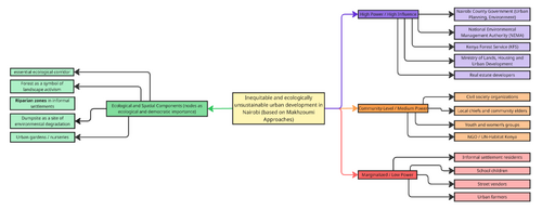
Landscape and Community Map
This processed community map visually represents the spatial organization and stakeholder dynamics in Nairobi’s urban landscape, highlighting the unequal distribution of green infrastructure and the exclusion of informal settlement residents from urban planning decisions. The map illustrates how government agencies, investors, and developers hold the greatest influence in shaping land use, while grassroots organizations, environmental activists, and marginalized communities have minimal representation. These disparities contribute to limited access to public parks, playgrounds, and ecological corridors, reinforcing social inequality and environmental degradation across different urban zones.
To promote sustainable and inclusive urban development, this map serves as a strategic advocacy tool, enabling policymakers, community leaders, and urban planners to visualize gaps in access and foster participatory planning. By integrating green infrastructure equitably, Nairobi can ensure that all citizens, including those from informal settlements, benefit from recreational and ecological spaces. Strengthening collaboration between stakeholders and implementing community-led initiatives will be essential in addressing urban disparities and advancing environmental justice within the city’s rapid urbanization framework.
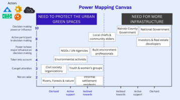
Power Map
Kenya’s urban development often prioritizes infrastructure expansion over equitable access to green spaces, leaving informal settlement residents marginalized in planning decisions. Despite constitutional guarantees for environmental rights, government agencies, investors, and developers hold the most power, making decisions that favor commercial interests while environmental activists, civil society groups, youth, and women’s organizations struggle to have their voices heard. As a result, these groups face displacement and exclusion, while high-ranking officials and investors remain largely unaffected. Though local chiefs and community elders may help mediate concerns, the imbalance in influence leaves community needs overlooked.
To achieve sustainable urban growth in Nairobi, green infrastructure, including urban forests, playgrounds, and public parks, must be integrated across all communities, ensuring inclusivity for residents in informal settlements. This requires participatory planning and advocacy, where historically excluded groups are given decision-making power alongside dominant stakeholders. By fostering an approach that values both development and environmental justice, Nairobi can work toward an urban future that serves all citizens, not just those with economic or political influence.
You can present your results in this gallery:
-
 This image visually represents the spatial relationships and stakeholder dynamics within the urban landscape, emphasizing local interactions, resource distribution, and community influence on development and environmental conservation.
 -
 The bottom image visually represents the interaction between urban development and green spaces, highlighting areas of environmental concern and stakeholder influence.


Your Team's Landscape Democracy Vision and Ideas (Phase C)
- Due: June 18
Collective Vision
If you were to redesign the power map of your area and start a process of democratic landscape transformation: Which long term-goal could keep the process going? What could be a collective vision that integrates the goals of your team? Give a name to your vision. Try to generate creative/conceptual/synthetic representation.
A prototype of the first step
How would you enter the process? Which prototype could activate it? How would you introduce the prototype to the community?
You can present your results in this gallery:


Cross-cutting activity: Readings, concepts and definitions (Phases A - D)
- Due: July 2, 2025
While working in your group, please start to express your personal understanding of the relation of landscape and democracy in the form of a concept map with linking words or any other diagrammatic representation. Please make your maps very visual and not just verbal. Think critically about why one map differs from another.
The final product is a shared concept map that integrates the various understandings present within your team.
About concept mapping
Before starting the exercise you can read this article by Joseph D. Novak & Alberto J. Cañas about Theory Underlying Concept Maps and How to Construct and Use Them. This paper gives a good explanation of how concept maps are conceived and developed.
You can use any tool you like for producing your concept map. However, since the result needs to be submitted digitally we recommend the following open source software for producing your maps:
- Cmap Tools >>> you can also work with your group on the Cmap cloud doing a shared map
- VUE - The Visual Understanding Environment
- Use a shared whiteboard to develop your integrated concept map, such as MIRO or MURAL
How to present your concept maps
- Possible format: JPG (for wiki upload) or link to any other resource
- We give you below a draft image gallery where you can add pictures of your map (in JPG or PNG format)
- You can present your integrated understanding as one concept map or your present individual ones and the integrated one.
- add as many additional materials as you need
Overview of your concept maps (individual and integrated)
-
 Ömer Cakir HfWU IMLA - Democratic Landscape Transformation Map
 -
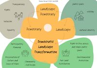
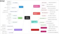 This map shows that transforming landscapes democratically isn’t just about design or nature ...................... it’s about justice, identity, voice, and inclusion. (NYAZ)
 -
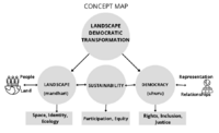
 Teresa - Democratic Landscape Transformation - Concept Map
 -
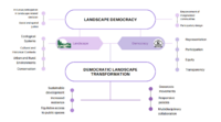
 Daniel Okumu - comcept.map-IMLA
 -
 Mark Kristofer R. Fajardo - Democratice Landscape Transformation Map
 -
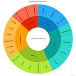 Integrated teamwork map


Please finish with a short reflection (Phase D)
Due: July 9, 2025
- What are the similarities and differences in your team regarding your understanding of what democratic landscape transformation is?
- In how far did the seminar lectures and readings help you to clarify this?
- What will you take home from this seminar?
- Similarities and differences in understanding of Democratic Landscape Transformation
As a team, we shared a common understanding that democratic landscape transformation is about inclusive, participatory, and just planning of public spaces that reflect the voices and needs of diverse communities. We all emphasized accessibility, equity, and the need to reshape power dynamics in landscape decision-making.
However, our interpretations varied based on our disciplinary backgrounds and cultural perspectives. For instance:
- Some members emphasized ecological and spatial design (e.g., Ömer and Teresa from architecture).
- Others (like Daniel and Nyaz) focused on policy, environmental justice, and community agency.
- Cultural context also shaped our lens - for example, navigating informality and marginalization in Nairobi brought different dimensions to the discussion compared to more structured urban settings in Europe.
These differences enriched our collective understanding, showed us that landscape democracy is context-specific, and must reflect local socio-political realities.
2. Role of Seminar lectures and readings
The lectures and readings were pivotal in clarifying and grounding our conceptual thinking. Key insights came from:
- Role models and activist case studies, which displayed real-world applications and innovative participatory methods.
- The Charta for Democratic Landscape Transformation, which gave us a shared framework for values like transparency, justice, and co-creation.
- Sessions on power mapping and community engagement helped us move from abstract ideas to practical tools and strategies.
These resources allowed us to critically examine our own biases and blind spots, especially regarding power asymmetries and inclusive governance in urban green space planning.
3. Takeaways from the Seminar
This seminar transformed how we think about space, power, and participation. We leave with:
- A deeper understanding that landscapes are political, i.e; they reflect who has voice, access, and agency.
- Practical tools like community mapping, power mapping, and prototyping, which we can use in our own contexts.
- The ability to work collaboratively across disciplines, cultures, and geographies, appreciating difference as a source of strength.
Above all, we take home the belief that landscape transformation must be democratic by design, driven not only by professionals, but co-created with the communities who live in, care for, and belong to these spaces.